Showing posts with label Ann Street. Show all posts

Tuesday, November 22, 2016

Port Richmond Project Part 4: (Port) Richmond Avenue between Ann and Bennett Streets

I hadn't planned to get many pictures from (Port) Richmond Avenue. My reluctance was based primarily on the poor quality of many of those photos. I got such a surprising amount of interest in the first three Port Richmond posts, though, I figure I might as well give it a go. So here we go.

One of the things I've been struck by over the years I've done this site is how ubiquitous Roulston's grocery stores were. I have a picture of one on Van Duzer Street, and I know there was another on Henderson and Davis. I've seen others as well, I just can't remember where right now. For an interesting read about the heirs of the chain's founder, go HERE.


It's hard to read the signs, but the one on the right is for "Foot Savers," an old shoe brand, so I'm guessing Anson Dansky was a shoe store. It's also another example of the house/store combo shown the other day.


I have no idea what the building on the left was other than an apartment. Whatever store was on ground level is a mystery. If anyone knows, let us know.


Toy stores also seemed to have been common as dirt in the "old" days. One block of Broad Street had two, while there was another across the street and one more a block away. I'm curious how more will turn up on (Port) Richmond Avenue as we work our way along it.


Dairy, Ex-Lax (a whole store of it?), dresses, and more. The original storefronts got covered up only a few years ago.


The shape remains, but the skin is completely covered over. That's really not surprising for a building that's at least eighty years old.


I'd love to find a picture of the original Masonic Hall. Clearly it was pretty big, as the property was taken up by three buildings.


Saturday, November 19, 2016

Port Richmond Project Part 3: Park Avenue between Ann and Church Streets and Church Street between Park and (Port) Richmond

Today we continue along the block bounded by (Port) Richmond Avenue, Church Street, Park Avenue, and Ann Street and then around the corner and down Church and back to (Port) Richmon. 

The stretch of Park Avenue shows us the first apartment building in this project. I wish I knew more of the history of the neighborhood's evolution. The F.W. Beers 1874 map shows Port Richmond as place of detached houses and large, open lots. By 1917, the town has started to become the place it remains today, a significant commercial avenue bounded by residential blocks, and some industrial sites scattered around the edges. 

This block of Church Street is another place where several of the old buildings have vanished. With the train overhead and non-residential neighbors, people weren't too keen on living there anymore. Or there was a fire. Lots of fires in the old days. 


You can see how the apartment has suffered from some modifications over the years. Two windows on the Park Avenue side have been sealed. Those little squares at the top right of the white rectangles are vents, so maybe dryers were installed. 
The pictures below show the usual removal of architectural detail. The arched window and door have had the muntins removed and the whole space cemented over. The multi-paned entrance door has been replaced with an ugly, metal slab door. Then there's the graffiti.


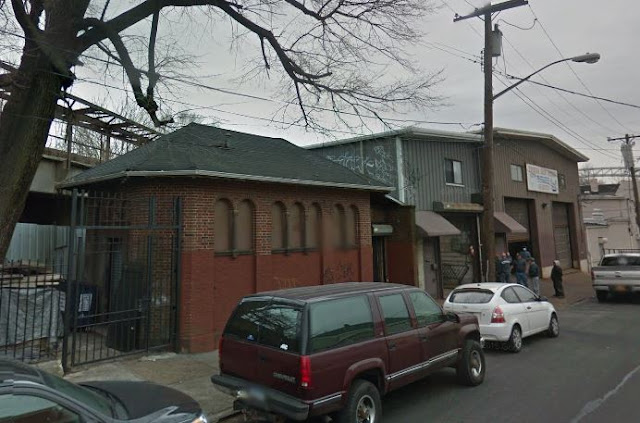
I don't know what this building was, though I guess it was connected to the old North Shore train line. It reminds me of the SIRT station at New Dorp. Today, it's privately owned and based on the sealed windows I think it might be used for storage.
UPDATE: Apparently, it was used as a public toilet in the forties and fifties.


The print shop is an interesting hybrid I've noticed in several other places in Port Richmond. A house has an extension built on to the front for commercial use. From what can be seen of the original house, it looks like the one next to it. 

On the right side of the picture you can see the back of Richmond Chandelier. The original lines of the building are there, just covered with cement or whatever.

G.W. Bromley 1917 Map


F.W. Beers 1874 Map

Thursday, November 17, 2016

Port Richmond Project Part 2: Ann Street between (Port) Richmond and Park Avenues

Today we slip under the old North Shore Rail overpass and then around the corner up along the northside of the first block of Ann Street. Unlike yesterday, this is a block with most of its older buildings still standing - which means we get to see the results of wear and tear over decades with limited upkeep. 

Nat's was the place we went for work boots and not much else. The store and the attached building are exemplars of the neighborhood's architectural decay. 

I've always found it interesting to see how close we used to live to shops. In this case, there are houses literally around the corner from a varied block of stores. As we move along in this project we'll see stores with large numbers of apartments above them. I'm curious what those apartments are like. I'd imagine they're a decent size. If Port Richmond ever takes off, I imagine they'll be worth a fortune.


Most of these houses have been transformed over the years between 1940 and today, suffering the usual disfiguring events. Windows and porches have been sealed up, attractive shingle siding covered with durable and dull aluminum, and curved window frames replaced with straight ones. I appreciate owners' need to cut down on maintenance expenses on old wooden houses, but the esthetics are awful.


 1917 Map 

Tuesday, November 15, 2016

(Port) Richmond Avenue between Ann and Church Streets - east side

I am not dead.

Port Richmond was still a flourishing commercial district when I was a little kid in the early seventies. From talking to folks older than myself, I learned it was even more impressive in the decades before that. There were theaters, department stores, and restaurants. To this day, if you stroll a block in either direction off Port Richmond Avenue, you can see numerous beautiful homes and churches.

In many ways, I find its current state of wear and tear more depressing than Stapleton. The latter neighborhood had whole sections wiped out, leaving nothing left except memories and old photos. Port Richmond was left to rot and fall to pieces. The Mexican community which sprang into existence over the past twenty years has restored much of the commercial activity, but it hasn't restored most of the dilapidated storefronts and the streets and sidewalks remain broken. Many of the surrounding houses and apartments look worn out and wasted.

After just having written about how much of old Port Richmond remains, the first picture I'm putting up is of a block almost completely obliterated. The only building still there is the Richmond Chandelier store on the corner of Church Street. Even that's been changed drastically, as you can see from the below street view. 


This NYC Archive photo is dated to around 1990. I'm not sure when it was covered up with the ugly, modern facing it has today, but clearly it was in serious need of updating. According to the store's website (follow the link), it was first opened in 1928, which makes the building at least 62 years old in the picture.