There are so many things about Deep Purple I love. Jon Lord's organ playing was easily one of the most important and distinctive parts of the band's sound. Rest in peace.

Tuesday, July 17, 2012
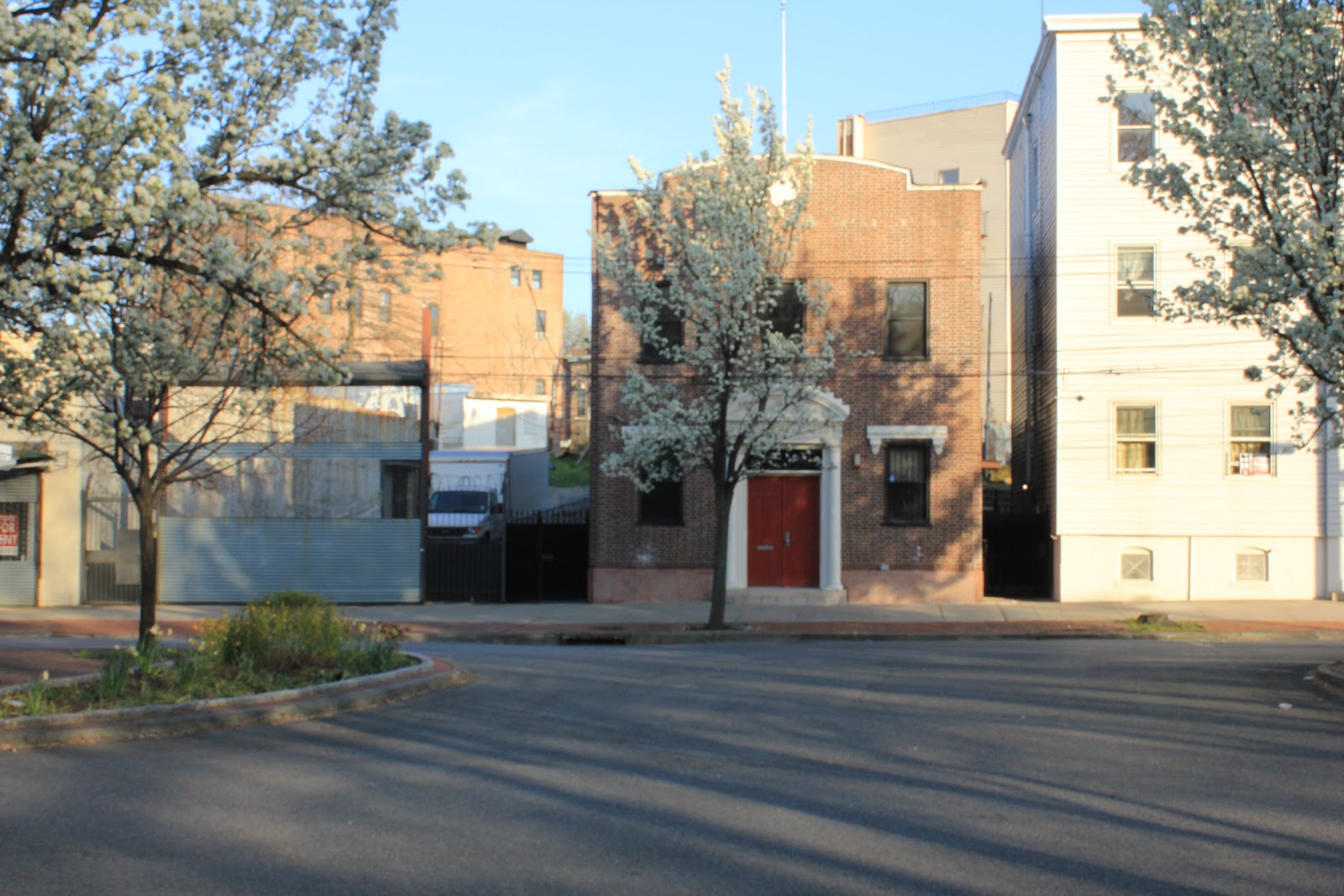
Forest Avenue

Sorry I've been so lax here for the longest time. I'm going to try to get back in the saddle and all that jazz and start writing/posting again. Here's an appetizer - Forest Avenue, 1917 from Greenwood Avenue all the way west to Bement Avenue.
It's a pretty amazing transformation over the past century. In the east there's the south extent of Sailors' Snug Harbor. Hart Boulevard running north from Forest served essentially as an entrance road. Now it's lined with houses.
The lot where the Starbucks sits at Bard and Forest (and before that, the much missed standalone Carvel Ice Cream - I like the iconic design much better than the same as everybody else storefront of present day Carvels) was the property and large home of one "H. O. Rambout". Most noticeably, though, was the absence of much housing at all. Most of that stretch of Forest, long a commercial hub, was tree lined and sparsely populated. Hard to imagine - if I didn't have the picture below you might just find it impossible.

Intersection of Bard and Forest Avenues
Wednesday, July 04, 2012
Happy Independence Day!

We weren't perfect then and we aren't perfect now. Along the way from then to now a lot of blood's been shed and often in ignoble circumstances. Nonetheless, we've done great things, overcome deep and dark flaws, and are ever moving forward bettering ourselves. For that, thank God. Some days I think we've still got a long way to go, but on most I'm just grateful for the actions take over two centuries ago that officially pushed this country into existence.
Saturday, June 09, 2012
Stapleton's Chinese Restaurants
Last year I posted pictures of the Chinese restaurant that used to be up on the second floor of a building near the old Woolworth's on Water Street in Stapleton. I only went there once when I was a little kid. The places I went to as a teenager and adult were Ying Wah and Tung Bo. Now, thanks to the city's absolutely amazing gallery of tax pictures from the mid to late 80s, here they are in gloriously, grainy color.


This seems to have been the older, more established of the two restaurants. It was definitely a better establishment with better food. Good memories.

This is the place I went to the most, first with my mom and sister (my dad hated anything that could be even vaguely label ethnic food) and later with friends. Fairly generic as I remember but pleasant enough and nice staff. As I older I came to appreciate their wide selection of ridiculous rum drinks in tiki head mugs.

Saturday, April 28, 2012
Vote for $$$ for Historical Preservation and Restoration

If you don't want to vote for a South Shore site, vote for Our Lady of Mount Carmel Shrine over in Rosebank. These two sites are small, underfunded and not on the radar for the big bucks like some of the more well known institutional sites on the Island. Any help they can get will, I imagine, be greatly appreciated.
Thursday, April 19, 2012
Farewell to a Southern Gentleman - Levon Helm, RIP
So passes the last of the Band's trio of vocalists (Richard Manuel in 1986 and Rick Danko in 1999) and the only American in such an American sounding and rooted group. The Band is one of greatest artifacts from the sixties and produced some of the best music in that era and which stands up under the weight of time and changing tastes much better than so many more fashionable artists' work. Taking from the pre-rock and roll sounds of America such as folk, country, blues and blue grass as well as early popular music, they embedded it in rock and made it even better. I may never need to hear "The Weight", "Up On Cripple Creek" or "The Night They Drove Old Dixie Down" again, but to miss out on "Ophelia", "Chest Fever", "King Harvest" and so many others would be painful.
Glorious Broad Street - Stapleton Again
The commercial heart of Stapleton is always assumed to be located at Canal and Water Streets along Tappen Park. Well that's probably accurate it neglects the stores that ran from Wright Street all the way up Broad Street to Van Duzer Street. According to my map reading skills that's about 1/2 a mile. Add to that Broad Street from Bay to Tompkins and you get another 1/4 of a mile. There half of the latter was pretty much residential, but still, that's about a mile's worth of stores catering to the needs and desires of Stapleton's citizens. Once you add in the Tappen Park surrounds and Bay Street, Stapleton probably had at least as much commercial property as Port Richmond did. Now much is gone or pretty low rent stuff. So it goes.


Broad and Targee, northwest corner - 1931


291,293 and 297 Broad Street at the corner of Targee - 1931

When I was a kid the building on the left housed a canine patrol. Its logo was a snarling dog's head. My sister's dance school was originally in the same building on the Targee Street side. It was called "Charing's Dance School" (or something very similar)

Broad and Targee, northwest corner - 1931

Same corner today - It was an empty lot even when I was a kid in the mid seventies - I remember doing a cleanup of it when I was in the Weblos or Boy Scouts which would have been around 1977.

Broad Street, east from Gordon Street - 1931

Today - the corner store was candy store with a soda fountain when I was kid. I only went once or twice but my mom and sister went there a bunch when she went to dance classes.

Broad, Canal and Tompkins - 1931

Today - Back in the early nineties the pizzeria (and as long as I can remember the building in the foreground has housed one) was called "Two Crusts". I don't get why but it did make us laugh when we ordered and they picked up the phone and said it.

Bonus Picture: Cop contemplating the world - 1931
Tuesday, April 03, 2012
Stapleton: Part One - Remembering and Ranting
For over thirty years Stapleton was my home. For all sorts of reasons my life revolved around the neighborhood. My mom would go shopping in Stapleton every week and we'd eat lunch at the Woolworth's luncheon counter. I went to the late school at Trinity Lutheran and my first on-the-books job was at the Stapleton Public Library.
My mother was intimately involved in trying to stave off the ultimate decline of Stapleton through a variety of community groups. She helped found something called the Friends of Stapleton Library but in the end the use of volunteers was limited by the employees union. Then she and the late Helen Pose, among others, invigorated the Stapleton Civic Association. That led to large, annual festivals and flea markets around Tappen Park.
Finally she launched the Stapleton LDC and was its first director. With a staff of three the LDC operated out of Stapleton Village Hall and secured grants for development and struggled to work with the merchants to preserve and encourage commerce in the town. They got the Village Hall refurbished and the gazebo and brick work installed.
All through this period there were lots people taking chances on businesses (ex. Cana's on Broad Street) and buying old homes and renovating them. People like Addison Branch and Cynthia Mailman reminded people of the beauty of Stapleton's architecture. Mud Lane was launched in 1977. The great and definitely not late Norma Herz (superstar children's librarian) brought Peter Seger and the Clearwater to the town on regular visits. There really seemed like some sort of renaissance was happening.
In the end it all sort of came to nothing. Over time the older businesses vanished (think John's Bargain Store, Store of A Million Items, the Army & Navy Stores, etc.) and the new didn't last or were more low end. The SI Mall helped drive a stake through the heart of Stapleton's shopping district just as it did Port Richmond's. But I think the greatest blow to Stapleton was its turning from a working and middle class neighborhood to a disproportionately poor one.
I just read the Mud Lane Society's history of the decline of Stapleton and it's a fascinating bit of myopia. They make it sound like only the blind eye of bad business killed Stapleton. They claim, though vacant for 13 years, the Piels Brewery could have been turned to some sort of "adaptive reuse" without providing any examples. They claim the Homeport only brought bars without noting that the base never became fully operational and filled with staff and families housed in nearby neighborhoods. High taxes, weak policing and changing economic demographics weren't the culprits according to them, or at least don't merit a mention.
Most importantly they never comment on the Stapleton Housing Projects. Once the City decided to focus on housing for welfare recipients instead of working class and municipal workers Stapleton started on a downward spiral it's never recovered from. Yes, many of the white residents fled because of the appearance of black residents. There's no denying the racism contained in white flight (if you read the SILIVE forums about Stapleton and took a shot at every racist comment regarding how great the neighborhood was you'd kill yourself) but it also holds an element of opposition to one's neighborhood being suddenly changed by influences out of your control. The economic circumstances are different, surely, but look at the reaction of long time residents in Harlem and Bushwick to gentrification.
Still, the problem with housing projects is that they lock an area into a permanent economic stratum. If you deliberately choose to make it the lowest economic one then there's going to be an effect. It's the government saying "This will now be a poor neighborhood forever".

The block bounded by Canal, Cedar, Boyd and Wright - 1917
As the middle-class consumer base that existed for the stores that ran from the top of Broad Street and Van Duzer all the way to Bay Street, along Bay and up Canal and Water Streets shrank the businesses suffered. In the eighties and early nineties drugs and crime helped kill off many that had straggled on by scaring away customers. Do you remember the last time you chose to go to the late Gelgisser's Hardware or Miller Drugs?
Today crime is a much decreased part life in Stapleton (thanks to Giuliani, Bratton and Bloomberg). Even though Woolworth's closed in 1997 (I think), the building has been occupied by the OZ Clothing since about the same time. Other shops appear to be thriving. Security helps lead to economic stability which leads to permanence. Maybe the businesses on Broad Street and along Tappen Park will remain. Maybe future Staten Islanders will be willing to continue taking a risk on Stapleton. Still, it's not enough and old commercial and residential buildings will continue to rot away.

Right to Left - The Rex Theater and neighboring buildings - 1936

Today it's a nearly empty stretch of grass and trees and the brick sidewalk that were supposed to presage a better tomorrow

Previously the Rex had been the Park Theater - co of Wright and Canal - 1930

Intrepid Development's refurbishing of the old Ross Cosmetics building (I can't remember what was in it before except for Golden Cue Pool Hall {and does anyone have a picture of their old advertisment?} and Wright Toy & Hobby used to be in the back)
+7-32.jpg)
172, 176 and 180 Canal Street - 1932 - The brick building at the center is the Baker School of Business - It's not on the 1917 map and 172 is no longer there today.
Same as above - today

160 Canal Street - 1932 - 1898 and 1907 maps list is as being the Hein home

160 Canal Street - today - this wonderfully odd house still stands though, mysteriously, the first floor windows in the front are boarded over.

from right to left - 209 to 232 Canal Street - 1936

215, 217, 219 Canal Street - today - all that remains of the commercial properties that once ranged from Wright Street to Cedar Street on the west side of Canal. The radio shop on the left of the old picture was only recently demolished.


Finally, the centerpiece of the block - The Rubsam & Horrmann Atlantic Brewery. I'm not sure when it was built though a decent portion of the plant is shown on the 1874 map of the area (below).

The top picture (1936) was taken from where Broad and Canal meet looking north toward Wright Street. At the far right you can make out the building in the lower picture (1930) which the maps designates a garage and storage facility. That clock tower forms such a part of my childhood memory. My buddy, Mike G., claimed his older friends had actually climbed up inside of it. Before I got my chance, and based on later exploits I definitely would have tried, it was gone. It was torn down in 1976 when I was ten. Later the city helped build housing much of the site and a park was created on the denuded stretch of Canal Street. It looked derelict then and only more so now.

Canal, Cedar, Boyd and Wright - 2012 - look at the transformation and desolation of the once vibrant commercial and industrial block.
Tuesday, March 27, 2012
More Van Duzer Pictures
A few more landmarks from Van Duzer and nearby blocks.

Fire Engine Co. 154 - This magnificent building still stands now converted to residential use.

This beautiful bit of advertising stood on that corner (Hannah btw Van Duzer and Bay) for decades only coming down in the late nineties (I think). It was torn down to make way for a car wash. Foolish if you ask me.

Our Lady of Consolation - Actually on St. Paul's Avenue but its large hall (behind it) was on Van Duzer. Today it's a dentist's parking lot. To its left is the derelict Fire Engine Co. 204 house.
Thursday, March 15, 2012
Van Duzer Street - blocks of wonder, sort of - Part One
All that being said, I'm not sure I'd want to live on Van Duzer Street myself. The traffic is heavy and constant and wouldn't want that outside my front door. I doubt it's ever truly quiet along the street. But it is a street with beautiful and interesting homes and buildings.


open the maps in a new tab so you can enlarge and zoom in on them
I debated (with myself, and it was contentious) about how to put up pictures to accompany these maps. They're a labor of love and I hope some of that love is contagious. I want people to look at them closely, think about what the street and surrounding blocks look like today, how they compare to each other, what they must have looked like in years past. All sorts of stuff.
One way to do that is simply present you (the readers) with photos with addresses but no key to their map location. To figure that out you'll have to search the maps. You can do it just by that. I've found so many surprising things in preparing these two maps I'm sure you'll find things I haven't noticed.
I think this is the sort of thing I'm going to be doing for the next several posts in general. If you don't think it's a good idea, please, let me know and I'll figure out something else to do. Thanks, as always, for reading and commenting on something I thoroughly and utterly enjoy doing.


35 to 51 Van Duzer, 4/1929 41 Van Duzer Street, 2/2012


63 Van Duzer (center), 3/1927 59, 63, and 67 Van Duzer, 2/2012

219, 221, 223 Van Duzer, 2/2012 - beautiful early to mid 19th century side gable houses
 226 Van Duzer, 5/1935

292 Van Duzer Street - left - 5/1935 (a this time it was the Democratic Club) - right - 2/2012


310 Van Duzer Street - left - 5/1935 - right - 2/2012
According to the NYC records on-line this home date to at least 1835 - a neighbor of it told me it was the oldest house on the block


324 Van Duzer Street - left - 5/1935 - right - 2/2012
The mighty fortress that is Trinity Lutheran Church can be easily seen on the hill overlooking Van Duzer Street. The "for sale" sign mention Cornelius G. Kolff. As an Islander of a certain vintage I only know the name as from the old ferry that got turned into a prison boat and then scrapped.
Turns out he was a major land developer, Staten Island promoter and folklorist and part-time philosopher. Most of this I actually came across in an article from the Northeast Tolkien Society.
So that's all for today. I've just got a ton of stuff to post and this is long enough. Hopefully tomorrow I'll get the rest up for your perusal.
Tuesday, March 06, 2012
I Was Born There
Well, not actually. I was born in the newer section but you know what I mean. Sadly, after three decades of neglect and misplaced trust that "somebody" would do "something" to save it, the Smith Infirmary was demolished by the City earlier today. The SILIVE has pictures and video.

I'm a little disappointed with myself for never going back and getting some better, closeup pictures of the building but it sure ain't happening now. So it goes. I wonder how many poorly built townhouses they're going to fit on the property.
I'm a little disappointed with myself for never going back and getting some better, closeup pictures of the building but it sure ain't happening now. So it goes. I wonder how many poorly built townhouses they're going to fit on the property.
Thursday, February 23, 2012
Stapleton: A Bit Of A Rant
I've bought my share of the Images of America books pertaining to Staten Island over the years. The one about the Jewish community is particularly compelling and actually filled with useful information and amazing pictures. I've never bothered, though to buy many more. Instead of solid information and pictures, they, the Irish community one in particular, seem really an excuse for lots of family pictures. I'm not saying it's a bad thing, just not something I need to spend twenty bucks on.
A few years back several neighborhood specific books came out and I got a little excited. There are so many things I don't know about that any new information is compelling. Unfortunately, when the Stapleton book came out (my hometown) I was pretty underwhelmed. There are good pictures and information, don't get me wrong, but it just didn't feel well put together.
 Paging through the book I was struck by the caption on a picture of the Elk's Club building on Van Duzer Street. It said that the exact location of the building was unknown. That surprised me. I was always pretty sure I knew which building it was myself (simply by looking at the buildings actually on Van Duzer Street). Still, maybe I was wrong and someday I'd have to look into it better.
Well, that day's come. I'm in the middle of working on a post concerning Van Duzer Street, from Beach to Victory and the Elk's Club came back up. So I drove on over with my camera and started getting some pictures.


I think the pictures make it pretty clear the building of yesterday is the building of today. Sure it's been stripped of any attractive detailing and windows have been blocked and the mansard roof has been obliterated. But it's the same building. If you drive down the street you can still see the porch that's in the left of the postcard on the house next door.
It was hard to get a clear picture of the lowest portions of the building but if you enlarge it you can see the same same basement windows with curved tops. There's the outcropping on the left towards the rear and the whole two stage outcropping at the front. Pretty terrible devastation was wrought on this building but it must have been a beast to maintain.


Here it is from today (sorry about the Google Maps picture, it's all I've got). Still there, though. I drove past it two days ago and it was STILL there. Probably still now.
View Larger Map
I know this sounds like I'm just griping. At a certain level I surely am, but you know what, if you're going to put out a book take some time to go see the places you're writing about. Look at the maps. Get it right or leave it out.
PPS - It still is. I just drove past it.
A few years back several neighborhood specific books came out and I got a little excited. There are so many things I don't know about that any new information is compelling. Unfortunately, when the Stapleton book came out (my hometown) I was pretty underwhelmed. There are good pictures and information, don't get me wrong, but it just didn't feel well put together.

Well, that day's come. I'm in the middle of working on a post concerning Van Duzer Street, from Beach to Victory and the Elk's Club came back up. So I drove on over with my camera and started getting some pictures.


I think the pictures make it pretty clear the building of yesterday is the building of today. Sure it's been stripped of any attractive detailing and windows have been blocked and the mansard roof has been obliterated. But it's the same building. If you drive down the street you can still see the porch that's in the left of the postcard on the house next door.
It was hard to get a clear picture of the lowest portions of the building but if you enlarge it you can see the same same basement windows with curved tops. There's the outcropping on the left towards the rear and the whole two stage outcropping at the front. Pretty terrible devastation was wrought on this building but it must have been a beast to maintain.


So here are the maps from 1874, 1885 and 1917. Same building footprint (save the added bowling alley in by 1917), same location. Not only is it listed as the Elk's Club on the 1917 map but on the two earlier maps it's designated the Methfessel Institute. That means it's probably the first incarnation of Staten Island Academy prior to its move to Academy Place (originally Carroll Place). I did this mostly sitting at a desk looking at easily available maps and pictures. That's actually a very cool discovery. The photos were really only for my own satisfaction as the maps say it all.
I'm not expert on the history and architecture of the North Shore, only a motivated amateur. I hope I never present myself here as anything more. Still, I hope never to steer you wrong or fail to follow down any leads I can find. Of course I will and I hope to hear from you and be corrected as swiftly as possible. The fluidity of a blog and the ease of correction is definitely one of its greatest assets and I hope to utilize that to the best of my ability.
PS: While working on the Van Duzer post I found myself looking at the Amazon listing for the Stapleton book to make sure I was remembering the Elk's Club picture caption correctly when I came across another serious error. Which of course makes me wonder how many more there might be.
This one concerns a "double house" on the north side of Beach Street between Jackson and Van Duzer Streets. According to the authors the building, looking quite picturesque in 1927, drifted off into derelict status before being demolished in the 21st century. Here's a shot similar to one in the book but from 1931.

View Larger Map
I know this sounds like I'm just griping. At a certain level I surely am, but you know what, if you're going to put out a book take some time to go see the places you're writing about. Look at the maps. Get it right or leave it out.
PPS - It still is. I just drove past it.
Subscribe to:
Posts (Atom)