View Larger Map Running parallel to Castleton Avenue for much of its generally east-west run, Forest Avenue is tied with Victory Blvd as the North Shore's most important commercial avenue. Starting at the crest of Victory Blvd.'s first great hill, Forest Ave. starts alongside Silver Lake Park and Golf Course. It then cuts its way through the southern portion of
West New Brighton. The stretch between Oakwood and Bement used to be called Peter Pan Alley because it was lined with Irish bars; the denizens were green and never grew up.
West New Brighton runs roughly from Hart Blvd to Jewett Avenue. From Jewett to Richmond Avenue Forest cuts Port Richmond off from
Westerleigh and
Willowbrook. At Richmond Avenue it separates
Elm Park and
Mariner's Harbor to its north from Graniteville before coming to an end in the marshlands of
Bloomfield.
The first lovely house was located on the north east corner of Oxford Place and Forest. Today it's a series of relatively unpleasant townhouses thrown up in the 90s. The second house is still standing on a beautiful block between Oxford and Duer Lane opposite Silver Lake Park.
Silver Lake - Oxford and Forest Silver Lake - Forest and Duer
 - This house was owned by Louis A. Dreyfus, a noted chewing gum magnate and Staten Island civic activist. He and his wife donated the land for Hero Park and supported numerous churches, schools and charities. IS 49 in Stapleton is named for his wife, Bertha.
 View Larger Map
 Today the intersection of Forest and Bard is a major commercial area with a Keyfood, drycleaners, a Starbucks and a CVS. Once upon a time it was a fairly sleepy (and dusty apparently) crossroads.
West N. Brighton - north side of intersection looking east along Forest Avenue View Larger Map
I had to blow up the bus just because I thinks its pretty nifty looking.

On the south side of the intersection is Our Savior Lutheran Church. I've mentioned in an earlier post how it was once the church in the basement. Well, here's proof.
 View Larger MapWest N. Brighton - Forest and Clove Road
 - This beautiful estate was owned by the Brooks family (who I have no idea who they were) and was called, imaginatively, Brooklawn) Today it's all gone and been replaced with the northern stretch of Clove Lake Park.
 Graniteville - Richmond Avenue between Forest Avenue and Monsey Place
 - Today Monsey doesn't even intersect with Richmond and there's a filthy gas station and convenience store on the spot. Good going, people.
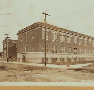
 Graniteville - PS 22 - Forest and Columbus Street
 (well, today, Columbus doesn't even exist and a new extension to the school's been built across its roadbed) - This picture from the early 30's shows the "new" extension built to the original school on the picture's left. Today another extension has been attached to this extension.
 View Larger Map


