Showing posts with label Mariners Harbor. Show all posts

Monday, October 31, 2022

Lost Small Churches of the North Shore: Italian Methodist Mission Chapel, Harbor Road


181 Harbor Road - Italian Mission Church, ca. 1940

This church is not so much lost as it was relocated and transformed. In 1919, Rev. Dr. Sante Buzzalini began preaching in Mariners Harbor, particularly to the Italian immigrants. He served out of Summerfield Methodist Church on Harbor Road. The goal was to found an English-language Italian congregation.


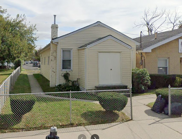
In 1922, after several years of meeting in Summerfield and open-air preaching, Rev. Buzzalini was granted permission to acquire a portable chapel. It was put in place at 181 Harbor Road where it still stands today. It is no longer a Methodist chapel, however.


181 Harbor Road, 2019

In 1939, following tremendous growth, the decision was made to build a more permanent building for the Italian congregation. A second chapel had been established by Rev. Buzzalini in nearby Bullshead that was to be combined with the Harbor Road chapel, so a central location on Forest Avenue was chosen. In 1939, Holy Trinity Methodist Episcopal Church opened. To quote the church's history page:
The church was built directly on the bedrock which gives Graniteville its name, and made of blocks from the quarry which was only a few hundred yards away.
During the great Methodist shakeout of the late sixties and early seventies, Trinity Methodist went through several changes. In 1959, Holy Trinity merged with Graniteville Methodist, and in 1960 the name was changed to Christ Methodist Church. In 1972, Asbury Methodist and Dickenson Methodist merged. This new congregation merged with Christ United Methodist (the United had been added in 1972 to reflect a merger between larger Methodist church bodies) in 1974, retaining the Christ United name. 

The old Harbor Road chapel has been a Pentecostal congregation of one sort or another since at least the forties. According to a commenter several years ago, it was a Pentecostal congregation from the moment the Rev. Buzzalini moved out. Originally, it appears to have served as the Refugee Church of Christ. In 1947, the building and the present sanctuary at 183 Harbor Road, were purchased by the United Pentecostal Church. Today it's called Pentecostal Tabernacle Church, a congregation of the United Pentecostal Church, a oneness denomination. 

Christ United Methodist Church, 1890 Forest Avenue - 2022


Thursday, December 30, 2010

Harbor Road revisited

West side of Harbor Road between Leyden and Richmond Terr. - Apr 23, 1932


View Larger MapSame view today

These shots of Harbor Road in Mariners Harbor start with the second house north of Summerfield United Methodist Church. All of the houses shown here are still in existence in one way or another. Let me show you.


Map 1874- The first house in the photo above is that of "Capt.Jones" followed by those of "F. Jones", "Capt. J. Wright", "M. Van Name", and "Capt. Tomlinson". I think I safe assuming that the captains here are oyster captains. A nice indication of the neighborhood's famous past.


View Larger Map
The Capt.Jones house - The porch columns match those in the photo but the railings and beautiful eaves and wood shingling have been removed or covered.


View Larger MapThe F. Jones House - All the beautiful detail has been removed and siding of some sort has covered up the wood shingle. The loss of the porch leaves this house a big blank, unattractive box.


View Larger Map
The first house, that of Capt. Wright, is presently greatly obscured by foliage (so I'm not showing it). You'll have to trust me when I write that the front porches have been removed.

The second, that of M. Van Name (and one of many in the neighborhood), is visible, as is the awful faux-brick asphalt shingle that now covers it. Similar to many of the captains' homes that once lined the Terrace, this house has always been one of my favorite.


View Larger Map
Finally, we have the house of Capt. Tomlinson. It's the most beautifully preserved of this series of houses, though the porch columns have lost their elaborate shapes and are simple four sided columns now and the decorative eaves is gone. Still, the dark trim and curved door is much to my liking.


Well, I suspect this is my last post for 2010. I hope you few readers have enjoyed my pretty slack efforts. I appreciate everyone's comments and I look forward to more feedback and questions in the coming year from everybody.

To everyone, a blessed and happy New Year!

Wednesday, December 29, 2010

Mariners Harbor - how many times is it?

East side of Van Pelt Avenue looking north to the Terrace


View Larger MapSame view (more or less) today - much of the detail appears to have been lost to siding and painting over the decades but it still remains a beautiful house. You can see the large home in the old picture's foreground was torn down and replaced with a smaller one, probably in the 20's.


I keep coming back to Mariners Harbor because it has the greatest collection of surviving old homes (admittedly, since the rape of South Avenue in the 90's, not that many large Victorian piles, and few in perfect condition) on the North Shore. Sure, the preservationists have protected their own homes on St. Paul's and St. Mark's, but for me the real gems are the simple homes tucked away in Mariners Harbor, Stapleton and Port Richmond. These, owned by people often unable to maintain them at all, let alone to the levels demanded by the crazy landmark regulations, are in the greatest danger of being lost.


For me, these houses, some of which date to the earliest part of the 19th century, represent the real woof and warp of life during Staten Island's past. Obviously I'm a sucker for the lost manors and suburban palaces of the Golden Age's magnates, but the places where the working and middle class people lived are my greatest joys. It's much easier for me to imagine, and have some sort of historical empathy for, those families, with their worries and activities.

People like the Stokes, the Vanderbilts and the Camerons lived lives filled with servants and wielded power and wealth beyond anything I'm in regular contact with. The doctors and lawyers, the oyster captains, the clerks, the farmers and brewery workers are the people I'm most interested in. I know, was, and am related to people just like this (okay, well not any oystermen).

These are the people who lost the most with the changes wrought on Staten Island over the past fifty years. Working class neighborhoods were what were destroyed by the advent of the housing projects. The highways that would have crossed Todt and Emerson Hills were stopped but not the one that cut Concord in two. These are the people forced to deal with overcrowded roads and often poorly constructed tract housing.

So that's what interests me and motivates much of what I do here. Don't get me wrong, I do want to know what all those demolished estates looked like, but if I can find more pictures like those on display today I'll be a little bit happier.

Thursday, November 12, 2009

Forest Avenue in Ole Tymes and Now


View Larger Map

Running parallel to Castleton Avenue for much of its generally east-west run, Forest Avenue is tied with Victory Blvd as the North Shore's most important commercial avenue. Starting at the crest of Victory Blvd.'s first great hill, Forest Ave. starts alongside Silver Lake Park and Golf Course. It then cuts its way through the southern portion of West New Brighton. The stretch between Oakwood and Bement used to be called Peter Pan Alley because it was lined with Irish bars; the denizens were green and never grew up.
West New Brighton runs roughly from Hart Blvd to Jewett Avenue. From Jewett to Richmond Avenue Forest cuts Port Richmond off from Westerleigh and Willowbrook. At Richmond Avenue it separates Elm Park and Mariner's Harbor to its north from Graniteville before coming to an end in the marshlands of Bloomfield.

The first lovely house was located on the north east corner of Oxford Place and Forest. Today it's a series of relatively unpleasant townhouses thrown up in the 90s. The second house is still standing on a beautiful block between Oxford and Duer Lane opposite Silver Lake Park.

Silver Lake - Oxford and Forest


Silver Lake - Forest and Duer - This house was owned by Louis A. Dreyfus, a noted chewing gum magnate and Staten Island civic activist. He and his wife donated the land for Hero Park and supported numerous churches, schools and charities. IS 49 in Stapleton is named for his wife, Bertha.


View Larger Map

Today the intersection of Forest and Bard is a major commercial area with a Keyfood, drycleaners, a Starbucks and a CVS. Once upon a time it was a fairly sleepy (and dusty apparently) crossroads.

West N. Brighton - north side of intersection looking east along Forest Avenue


View Larger Map

I had to blow up the bus just because I thinks its pretty nifty looking.


On the south side of the intersection is Our Savior Lutheran Church. I've mentioned in an earlier post how it was once the church in the basement. Well, here's proof.


View Larger Map


West N. Brighton - Forest and Clove Road - This beautiful estate was owned by the Brooks family (who I have no idea who they were) and was called, imaginatively, Brooklawn) Today it's all gone and been replaced with the northern stretch of Clove Lake Park.


Graniteville - Richmond Avenue between Forest Avenue and Monsey Place - Today Monsey doesn't even intersect with Richmond and there's a filthy gas station and convenience store on the spot. Good going, people.


Graniteville - PS 22 - Forest and Columbus Street (well, today, Columbus doesn't even exist and a new extension to the school's been built across its roadbed) - This picture from the early 30's shows the "new" extension built to the original school on the picture's left. Today another extension has been attached to this extension.


View Larger Map

Saturday, October 17, 2009

The other remaining Methodists

Summerfield Methodist Church - 104 Harbor Road - Mariners' Harbor


View Larger Map


Christ United Methodist Church - 1890 Forest Avenue - Graniteville


View Larger Map


I did a little mucking around on the United Methodist Church's website to see what I could discern about Methodism on the Island. The numerous remaining churches (there are several more on the South Shore) are all barely hanging on with tiny congregations (except two of the Korean congregations). If you go to the other boroughs there are huge congregations. So I still don't have my answers and I continue to be intrigued.

Tuesday, June 16, 2009

Mariners Harbor Day

Mariner's Harbor (I haven't linked to wikipedia here because the entry seems racist and I suspect contains and urban legend) presents the best neighborhood to look around at for cool old pictures and surviving old buildings. It's been a heavy industrial area, was and remains a working class neighborhood with an always diverse populations, and at one time was the heart of the Island's wealthy oystering community.

Because of various economic and demographic prejudices the Harbor stayed fairly intact (in regards to its older housing stock) till fairly recently. The beautiful big Victorian houses on along the north end of South Avenue were only demolished in the last decade or so (and even now one or two survive, crowded all around by the townhouses wedged onto the lots of their now lost compatriots). Even a few of the old captains' mansions along Richmond Terrace have stumbled along into the 21st Century.

Whenever I'm stuck for something to put up on the site I've been able to just troll through the Mariner's Harbor pictures on the NYPL site and just post away. I hope you enjoy the pictures.

47 Union Avenue


47 Union Avenue - 1932 - The NYPL information says a plaque over the door read "Horse Shoer and Blacksmith"


View Larger Map

Today

St. Michael's Church - Harbor Road and Brabant Street


Looking at St. Michael's Church at Harbor and Brabant from the west along Lockman Avenue - In the distance you can see PS 44.


View Larger Map

Today - Now called St. Clement's and St. Michael's. It's a poor quality googlemaps pictures but it's what I've got to work with at work.

The Post House


The Post House - 1900 - located on the south side of Richmond Terrace several hundred yards west of Holland Avenue. According to the NYPL it was built in 1691.


View Larger Map

Today

Fernic Aircraft Corporation


3493 Richmond Terrace (northside) - 1931


View Larger Map

Today

The Fernic Aircraft Corporation was founded by Romanian aviator George Fenric in 1929. He died in 1930 when he crashed at an air show on Curtiss Reynolds airfield in Chicago, Illinois, on October 22, 1930.

Tuesday, June 09, 2009

Mariner's Harbor - remants of a oysteriffic past


2846 Richmond Terrace - from 1924 - the homes of George and John Thompson, both in the oyster business


View Larger Map


18 South Avenue - at these times it belonged to M.A. Sinn. Prior to that it belonged to G. Hart

1924


1932


View Larger Map
c. 2007

Thursday, May 14, 2009

Bethlehem Steel in Mariner's Harbor


There was a period when Staten Island was an industrial town. In Mariner's Harbor, Bethlehem Steel built destroyers during WW II. They closed up shop in the late fifties but several of the buildings still remain, converted to other uses or simply left to rot.


View Larger Map
The size of this shipyard was huge.


View Larger Map

Buildings on Davidson Street - rotted, rusting remnants


View Larger Map

Buildings at Andros and Richmond Terrace - the building on the extreme right's been converted into a mosque.