Showing posts with label Richmond Avenue. Show all posts

Thursday, June 15, 2017

Port Richmond Project Part 7: West side of (Port) Richmond Avenue between the train overpass and Grove Avenue

It's been a long time since I put up any pictures of Port Richmond Avenue, so here's a batch. As most of the street is still today, it's mostly commercial with apartments on top. Most of the buildings in the photos from the thirties are still there today, but they've been marred with ugly facades, tattered signage, and a general grubbiness. The latter I attribute to a combination of municipal and community neglect. That it's such a bustling avenue, you'd think that would be enough to encourage both the city and property owners to do a better job of taking care of it. Right.

So, let's get started. Oh, by the way, I've updated the previous post from West New Brighton and included the maps.


This building, now gone, was still there in the late 1980s (see below)


So, funny thing. There's no photo of the Palace Theater among the regular batch. If I can find one later (lots of the pictures were damaged, retaken, then allocated to catchall files. Usually, finding them means lucky) I'll put it up.


I spent a lot of time with my mom in the Port Richmond Woolworth when I was little. I don't remember what she bought there, but I know I got several model planes from there. I was surprised to see how close to the Terrace the store was. My memory had it further south, closer to, or even past, Castleton Avenue.


1917 map - Several of the buildings didn't exist this far back in time. It looks like the building on the corner of Grove (#123) was a single family house back then. 


Tuesday, November 15, 2016

(Port) Richmond Avenue between Ann and Church Streets - east side

I am not dead.

Port Richmond was still a flourishing commercial district when I was a little kid in the early seventies. From talking to folks older than myself, I learned it was even more impressive in the decades before that. There were theaters, department stores, and restaurants. To this day, if you stroll a block in either direction off Port Richmond Avenue, you can see numerous beautiful homes and churches.

In many ways, I find its current state of wear and tear more depressing than Stapleton. The latter neighborhood had whole sections wiped out, leaving nothing left except memories and old photos. Port Richmond was left to rot and fall to pieces. The Mexican community which sprang into existence over the past twenty years has restored much of the commercial activity, but it hasn't restored most of the dilapidated storefronts and the streets and sidewalks remain broken. Many of the surrounding houses and apartments look worn out and wasted.

After just having written about how much of old Port Richmond remains, the first picture I'm putting up is of a block almost completely obliterated. The only building still there is the Richmond Chandelier store on the corner of Church Street. Even that's been changed drastically, as you can see from the below street view. 


This NYC Archive photo is dated to around 1990. I'm not sure when it was covered up with the ugly, modern facing it has today, but clearly it was in serious need of updating. According to the store's website (follow the link), it was first opened in 1928, which makes the building at least 62 years old in the picture.


Thursday, November 12, 2009

Forest Avenue in Ole Tymes and Now


View Larger Map

Running parallel to Castleton Avenue for much of its generally east-west run, Forest Avenue is tied with Victory Blvd as the North Shore's most important commercial avenue. Starting at the crest of Victory Blvd.'s first great hill, Forest Ave. starts alongside Silver Lake Park and Golf Course. It then cuts its way through the southern portion of West New Brighton. The stretch between Oakwood and Bement used to be called Peter Pan Alley because it was lined with Irish bars; the denizens were green and never grew up.
West New Brighton runs roughly from Hart Blvd to Jewett Avenue. From Jewett to Richmond Avenue Forest cuts Port Richmond off from Westerleigh and Willowbrook. At Richmond Avenue it separates Elm Park and Mariner's Harbor to its north from Graniteville before coming to an end in the marshlands of Bloomfield.

The first lovely house was located on the north east corner of Oxford Place and Forest. Today it's a series of relatively unpleasant townhouses thrown up in the 90s. The second house is still standing on a beautiful block between Oxford and Duer Lane opposite Silver Lake Park.

Silver Lake - Oxford and Forest


Silver Lake - Forest and Duer - This house was owned by Louis A. Dreyfus, a noted chewing gum magnate and Staten Island civic activist. He and his wife donated the land for Hero Park and supported numerous churches, schools and charities. IS 49 in Stapleton is named for his wife, Bertha.


View Larger Map

Today the intersection of Forest and Bard is a major commercial area with a Keyfood, drycleaners, a Starbucks and a CVS. Once upon a time it was a fairly sleepy (and dusty apparently) crossroads.

West N. Brighton - north side of intersection looking east along Forest Avenue


View Larger Map

I had to blow up the bus just because I thinks its pretty nifty looking.


On the south side of the intersection is Our Savior Lutheran Church. I've mentioned in an earlier post how it was once the church in the basement. Well, here's proof.


View Larger Map


West N. Brighton - Forest and Clove Road - This beautiful estate was owned by the Brooks family (who I have no idea who they were) and was called, imaginatively, Brooklawn) Today it's all gone and been replaced with the northern stretch of Clove Lake Park.


Graniteville - Richmond Avenue between Forest Avenue and Monsey Place - Today Monsey doesn't even intersect with Richmond and there's a filthy gas station and convenience store on the spot. Good going, people.


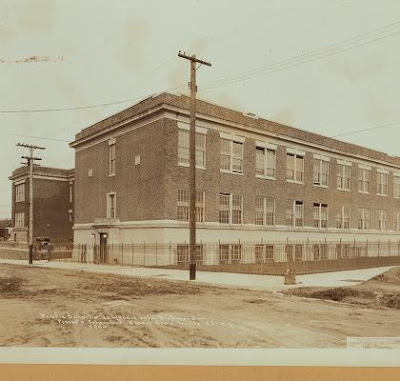
Graniteville - PS 22 - Forest and Columbus Street (well, today, Columbus doesn't even exist and a new extension to the school's been built across its roadbed) - This picture from the early 30's shows the "new" extension built to the original school on the picture's left. Today another extension has been attached to this extension.


View Larger Map

Thursday, June 18, 2009

Port Richmond Avenue and Orange Avenue


620 Port Richmond Avenue - seems to have been built in 1899 (though I suspect before then)


View Larger Map

Today