
Monday, March 21, 2011
Patell and Waterman's History of New York
I've added Pattell and Waterman's History of New York site to the blogroll on the right. They've linked to me in the past and I've never really returned the courtesy. They a way more serious and academic site than this one so you should really spend some time and check them out instead of wasting your time here.


Thursday, March 17, 2011
Port Richmond - some quick and easy shots of back streets
Here are some houses scattered across Port Richmond that I find attractive. They're just regular homes, none of particular historic or architectural significance. They're just here to show off the visually pleasing place that is Port Richmond.
I didn't list addresses because you should take some time and drive along the area's back streets and find the houses on your own.
View Larger Map
Faber Street
View Larger Map
Faber and Harrison
View Larger Map
Sharpe Avenue - peekaboo
View Larger Map
Sharpe Avenue - again
View Larger Map
Clinton Place
I didn't list addresses because you should take some time and drive along the area's back streets and find the houses on your own.
View Larger Map
Faber Street
View Larger Map
Faber and Harrison
View Larger Map
Sharpe Avenue - peekaboo
View Larger Map
Sharpe Avenue - again
View Larger Map
Clinton Place
Thursday, March 03, 2011
Fraternal Port Richmond

 NE corner of Bennett and Port Richmond Avenues, 1905 - Masonic Hall - same place, 2011
Once upon a time Americans bonded with each other at all sorts of fraternal organizations. At the organization's height in 1959 there were just over 4 million Masons in American. Notably there were huge numbers of Elks, Moose, Eagles and Odd Fellows as well.
Today the Masons have dropped below the 2 million mark. At the same time the country's population climbed from 179 million to 308 million. I don't know how high the others groups were in the past but I feel safe in assuming their numbers have shrunk as well.


Loyal Order of Moose Club House on the corner of Bennett and Park, 1927 - same corner, 2011
More knowledgeable people than your humble blogger have examined the question of declining American civic and community participation (see Robert Putnam's "Bowling Alone") but I have to wonder why Americans have really turned inward to such an astonishing degree. What turned us from a society of inveterate joiners and boosters into isolated little family units? Is it all the tv and internet that's cut us off from our fellows? I'm not even saying it's a bad thing (if you don't know, I was the kid in corner with his nose in a book), it's just such a drastic change in such a little bit of time.
Once upon a time Port Richmond was home to many of these organizations, hosting large facilities they built with the dues of their members. On Bennett Street you had the Masons and the Moose. A few blocks west on Harrison Street was the Independent Order of Odd Fellows. One lot west of Faber Street on Richmond Terrace was the Knights of Columbus' house.

2180 Richmond Terrace, 1932 - Knights of Columbus Assumption Council 1694
According to information from rootsweb, in 1888, the Order of United American Mechanics (a nativist group) had two chapters meeting in a public hall in the neighborhood and the Grand Army of the Republic had its own hall.
Later the Masons built a more magnificent hall on Anderson Avenue.

Eventually, though, they closed up shop and sold the facility to the CYO. From numerous North Shore lodges they've been reduced to one in Stapleton (Tompkins No. 471 to be precise).
 The Moose sold their property and bought an old Lutheran church on Nicholas Avenue and the Odd Fellows' nearest location appears to be near West Point. The other groups I listed don't even exist anymore.
 once the Independent Order of Odd Fellows Hall, now an apartment - Harrison Street
Tuesday, March 01, 2011
PORT RICHMOND - and I mean it
The first of several planned posts on Port Richmond.

Without a doubt Port Richmond has the potential to be the greatest neighborhood on Staten Island. Much of its old housing stock has survived the despoliation that ravaged so many older neighborhoods on the Rock. Right off Port Richmond Avenue is Veterans' Park, towered over by the great edifice of P.S. 20, and surrounded by several churches and pleasant pre-war apartment buildings. Architecturally, few neighborhoods have held onto such a significant portion of its past as Port Richmond. Even the simple residential back streets hold significant and attractive homes. In its layout and buildings it is still one of the most pleasing looking parts of Staten Island.
Along Port Richmond Avenue are countless commercial buildings, large and small, many with office space and apartments on their upper floors. At present the neighborhood is well served by several bus lines. But, if the North Shore rail was ever actually built or the Borough President's excellent idea for a bus linkage to the NJ light rail in Bayonne were implemented Port Richmond's stock would go through the roof. It could become the starting point of one of the fastest Manhattan commutes going.
Unfortunately, once New York City decided to allow itself to become dependent on cheap, often illegal, immigrant labor, places had to be designated for them to live. On Staten Island, Port Richmond, much of it a troubled neighborhood by the early nineties when this trend began, drew the short straw. Soon men, working tough, physically exhausting jobs in many cases, were living together packed into poorly maintained apartments. Only later did immigrant families take root and businesses to serve them specifically open.
Much of the Port Richmond of today is one of decayed commercial properties, poor or little municipal maintenance (I dare you to drive either way on Port Richmond Avenue in a straight line without ripping out your car's underside on a pothole or sudden depression in the roadbed), several slumlike apartments, and a steady level of distrust between the African-American and Mexican residents. The latter led to the present near occupation of the neighborhood (at least the section between Nicholas, Castleton, Heberton and the Terrace) by units from the 120th Precinct.
Like much of Staten Island, Port Richmond is an oddly dichotomous place. North of Castleton Avenue has a mostly African-American and Mexican population and there is substantial poverty and several abandoned, tattered houses. South of Castleton Avenue is white, black and all shades of brown and the home of such stalwart Port Richmond businesses as Denino's Pizza, Ralph's Ices and Merlino Photo Studios.

The possibility of the northern section becoming attractive is very real in the light of improved transportation. I don't know how this would happen though without many of the poor or minority residents being forced out. But if the travel time to Manhattan is reduced I see it happening and I don't suspect it will be a pretty event.

Without a doubt Port Richmond has the potential to be the greatest neighborhood on Staten Island. Much of its old housing stock has survived the despoliation that ravaged so many older neighborhoods on the Rock. Right off Port Richmond Avenue is Veterans' Park, towered over by the great edifice of P.S. 20, and surrounded by several churches and pleasant pre-war apartment buildings. Architecturally, few neighborhoods have held onto such a significant portion of its past as Port Richmond. Even the simple residential back streets hold significant and attractive homes. In its layout and buildings it is still one of the most pleasing looking parts of Staten Island.
Along Port Richmond Avenue are countless commercial buildings, large and small, many with office space and apartments on their upper floors. At present the neighborhood is well served by several bus lines. But, if the North Shore rail was ever actually built or the Borough President's excellent idea for a bus linkage to the NJ light rail in Bayonne were implemented Port Richmond's stock would go through the roof. It could become the starting point of one of the fastest Manhattan commutes going.
Unfortunately, once New York City decided to allow itself to become dependent on cheap, often illegal, immigrant labor, places had to be designated for them to live. On Staten Island, Port Richmond, much of it a troubled neighborhood by the early nineties when this trend began, drew the short straw. Soon men, working tough, physically exhausting jobs in many cases, were living together packed into poorly maintained apartments. Only later did immigrant families take root and businesses to serve them specifically open.
Much of the Port Richmond of today is one of decayed commercial properties, poor or little municipal maintenance (I dare you to drive either way on Port Richmond Avenue in a straight line without ripping out your car's underside on a pothole or sudden depression in the roadbed), several slumlike apartments, and a steady level of distrust between the African-American and Mexican residents. The latter led to the present near occupation of the neighborhood (at least the section between Nicholas, Castleton, Heberton and the Terrace) by units from the 120th Precinct.

Like much of Staten Island, Port Richmond is an oddly dichotomous place. North of Castleton Avenue has a mostly African-American and Mexican population and there is substantial poverty and several abandoned, tattered houses. South of Castleton Avenue is white, black and all shades of brown and the home of such stalwart Port Richmond businesses as Denino's Pizza, Ralph's Ices and Merlino Photo Studios.

The possibility of the northern section becoming attractive is very real in the light of improved transportation. I don't know how this would happen though without many of the poor or minority residents being forced out. But if the travel time to Manhattan is reduced I see it happening and I don't suspect it will be a pretty event.
Friday, February 25, 2011


Tuesday, February 22, 2011
Stapleton Chinese Restaurant (and it's NOT Tung Bo)

97-99 Water Street, Stapleton - 1931
When I was a kid Chinese restaurants were not that common and many tended to be of the Jade Island "Polynesian" variety. Today, of course, they're everywhere and some are quite good. My first memory of eating in one was in Stapleton in the very early seventies. It struck my five-year-old self as very exotic and very great. I remember the food was like nothing I had had ever had before and I liked it.
 You can't see the restaurant's name but you can see the wonderful Chinese-style awning and the curtains and decorations on the second-floor window in detail.
I can't remember its name right now, but it was originally located up on the second floor of a building on Water Street in Stapleton two storefronts down from the late and lamented Woolworths.
At some point, it moved half a block away to Beach Street and remained there into the eighties. Eventually, it closed and was replaced by a hair salon. You can still see the outline of the Chinese style entrance and small windows that marked its existence.
You can't see the restaurant's name but you can see the wonderful Chinese-style awning and the curtains and decorations on the second-floor window in detail.
I can't remember its name right now, but it was originally located up on the second floor of a building on Water Street in Stapleton two storefronts down from the late and lamented Woolworths.
At some point, it moved half a block away to Beach Street and remained there into the eighties. Eventually, it closed and was replaced by a hair salon. You can still see the outline of the Chinese style entrance and small windows that marked its existence.

View Larger Map NOTE: I'd like to know more about the history of Chinese-Americans on Staten Island. Growing up I didn't encounter too many but from my readings I know that at one point there were like a dozen Chinese laundries on Jersey Street with more about the Island. The restaurant above was opened in at lest 1931 and remained open for more than fifty years. That's a remarkable history. I'd like to know who these immigrants were, what drew them here and what happened to them.
 You can't see the restaurant's name but you can see the wonderful Chinese-style awning and the curtains and decorations on the second-floor window in detail.
I can't remember its name right now, but it was originally located up on the second floor of a building on Water Street in Stapleton two storefronts down from the late and lamented Woolworths.
At some point, it moved half a block away to Beach Street and remained there into the eighties. Eventually, it closed and was replaced by a hair salon. You can still see the outline of the Chinese style entrance and small windows that marked its existence.
You can't see the restaurant's name but you can see the wonderful Chinese-style awning and the curtains and decorations on the second-floor window in detail.
I can't remember its name right now, but it was originally located up on the second floor of a building on Water Street in Stapleton two storefronts down from the late and lamented Woolworths.
At some point, it moved half a block away to Beach Street and remained there into the eighties. Eventually, it closed and was replaced by a hair salon. You can still see the outline of the Chinese style entrance and small windows that marked its existence. 
View Larger Map NOTE: I'd like to know more about the history of Chinese-Americans on Staten Island. Growing up I didn't encounter too many but from my readings I know that at one point there were like a dozen Chinese laundries on Jersey Street with more about the Island. The restaurant above was opened in at lest 1931 and remained open for more than fifty years. That's a remarkable history. I'd like to know who these immigrants were, what drew them here and what happened to them.
Wednesday, February 09, 2011
John Barry RIP
He did tons and tons of great music but it's going to be the Bond stuff that people will most remember. The swagger in the music complements Sean Connery's Bond perfectly. And it really sort of swings.
Gary Moore - RIP
I wasn't a particular fan of his solo work but with Phil Lynott and Thin Lizzy he burned up the stage.
Tuesday, February 01, 2011
The Rorengo House

The Home of Domenico Rorengo (according to 1917 maps) - pictured in 1932
Here's a interesting home that once stood at the end of Buchanan Street where it used to intersect with York Avenue. I've meant to get this picture up for some time now but my usual predilection for wasting time let to not doing that.
Recently I received a lengthy and informative e-mail from a reader, Richard M., who grew up in Hamilton Park from the 50s through the 70s. I plan to make as much use of the information he sent me as possible for this and future posts.
Apparently, according to my new information, while the original source of Domenico Rorengo's money is not known, what is known is that he lost it in the market crash of 1929. His family held onto to the property but ultimately lost it in the 40s.
The house in the picture was damaged by fire in the 50s but remained occupied by a neighborhood character known as "the captain" through the 70s. If anyone has anymore information on THAT, feel free to drop me line.


Today the property is filled with town houses built in the past decade or so. I think perhaps the grade of the present site is the same as that in the picture but beyond that nothing remains.
View Larger Map
Wednesday, January 12, 2011
Clifton Berley
In one of last December's posts I wrote about about Miss Anne Flemming Cameron's wedding in 1895. It mentioned that she and the wedding party left the church to attend a reception at her father Sir Roderick Cameron's Arrochar country steading "Clifton Berley". Well, here it is in a state of fading glory.


"Clifton Berley" was Sir Roderick's 150-acre estate that he purchased in 1861. There, he spent much time and money importing, breeding and raising thoroughbred horses. A listing for a large collection of horse racing documents on Christie's web site included several from Sir Roderick. Apparently, some of Sir Roderick's horses were some of the best of their time.

Clifton Berley Barn - May 4, 1932

Sir Roderick died in 1900 and I don't know how long his family retained ownership of "Clifton Berley". However, by the time of these pictures in the May of 1932, the once beautiful mansion was a decaying hulk. Significant patches of tiles are gone from the roof and I strongly suspect that on the other side of the roof's peak has holes in it. The road around the house is in obvious disrepair. I imagine these pictures are final documents of the house before its demolition.
Today there is almost nothing to indicate the house was ever there. Its rolling grounds and fields are covered with asphalt and dozens of houses. The only vestige of Sir Roderick's forty years of ownership is his name on the small lake to the west of where his home once stood.
View Larger Map
Radcliff Road, northside, between Steuben and Briarcliff
I know posting a mansion so soon after some of my recent comments seems a tad out of place but this was a beautifully serendipitous finding.


Top Map - 1917 - The red circle is the house and the blue the barn
Bottom Map - 2011 - Again, red circle is the barn


"Clifton Berley" was Sir Roderick's 150-acre estate that he purchased in 1861. There, he spent much time and money importing, breeding and raising thoroughbred horses. A listing for a large collection of horse racing documents on Christie's web site included several from Sir Roderick. Apparently, some of Sir Roderick's horses were some of the best of their time.

Clifton Berley Barn - May 4, 1932

Sir Roderick died in 1900 and I don't know how long his family retained ownership of "Clifton Berley". However, by the time of these pictures in the May of 1932, the once beautiful mansion was a decaying hulk. Significant patches of tiles are gone from the roof and I strongly suspect that on the other side of the roof's peak has holes in it. The road around the house is in obvious disrepair. I imagine these pictures are final documents of the house before its demolition.
Today there is almost nothing to indicate the house was ever there. Its rolling grounds and fields are covered with asphalt and dozens of houses. The only vestige of Sir Roderick's forty years of ownership is his name on the small lake to the west of where his home once stood.
View Larger Map
Radcliff Road, northside, between Steuben and Briarcliff
I know posting a mansion so soon after some of my recent comments seems a tad out of place but this was a beautifully serendipitous finding.


Top Map - 1917 - The red circle is the house and the blue the barn
Bottom Map - 2011 - Again, red circle is the barn
Thursday, January 06, 2011
York Avenue, New Brighton
A quick display looking south at the east side of York Avenue between E. Buchanan and Carlyle Streets. Once upon a time York Avenue was a good looking working class street running parallel to Jersey Street. There were large homes on the hill to the west and even a few shops and at one point a German Lutheran church in addition to St Stanislaus Kostka Catholic Church.
Today much of York Avenue has clearly seen better days, but this stretch of houses is pretty unchanged from July, 1932.


Today much of York Avenue has clearly seen better days, but this stretch of houses is pretty unchanged from July, 1932.


Thursday, December 30, 2010
Harbor Road revisited
 West side of Harbor Road between Leyden and Richmond Terr. - Apr 23, 1932
View Larger MapSame view today
These shots of Harbor Road in Mariners Harbor start with the second house north of Summerfield United Methodist Church. All of the houses shown here are still in existence in one way or another. Let me show you.
 Map 1874- The first house in the photo above is that of "Capt.Jones" followed by those of "F. Jones", "Capt. J. Wright", "M. Van Name", and "Capt. Tomlinson". I think I safe assuming that the captains here are oyster captains. A nice indication of the neighborhood's famous past.
View Larger Map
The Capt.Jones house - The porch columns match those in the photo but the railings and beautiful eaves and wood shingling have been removed or covered.

View Larger MapThe F. Jones House - All the beautiful detail has been removed and siding of some sort has covered up the wood shingle. The loss of the porch leaves this house a big blank, unattractive box.

View Larger Map
The first house, that of Capt. Wright, is presently greatly obscured by foliage (so I'm not showing it). You'll have to trust me when I write that the front porches have been removed.
The second, that of M. Van Name (and one of many in the neighborhood), is visible, as is the awful faux-brick asphalt shingle that now covers it. Similar to many of the captains' homes that once lined the Terrace, this house has always been one of my favorite.

View Larger Map
Finally, we have the house of Capt. Tomlinson. It's the most beautifully preserved of this series of houses, though the porch columns have lost their elaborate shapes and are simple four sided columns now and the decorative eaves is gone. Still, the dark trim and curved door is much to my liking.
Well, I suspect this is my last post for 2010. I hope you few readers have enjoyed my pretty slack efforts. I appreciate everyone's comments and I look forward to more feedback and questions in the coming year from everybody.
To everyone, a blessed and happy New Year!
Wednesday, December 29, 2010
Mariners Harbor - how many times is it?
 East side of Van Pelt Avenue looking north to the Terrace
 View Larger MapSame view (more or less) today - much of the detail appears to have been lost to siding and painting over the decades but it still remains a beautiful house. You can see the large home in the old picture's foreground was torn down and replaced with a smaller one, probably in the 20's.
I keep coming back to Mariners Harbor because it has the greatest collection of surviving old homes (admittedly, since the rape of South Avenue in the 90's, not that many large Victorian piles, and few in perfect condition) on the North Shore. Sure, the preservationists have protected their own homes on St. Paul's and St. Mark's, but for me the real gems are the simple homes tucked away in Mariners Harbor, Stapleton and Port Richmond. These, owned by people often unable to maintain them at all, let alone to the levels demanded by the crazy landmark regulations, are in the greatest danger of being lost.
For me, these houses, some of which date to the earliest part of the 19th century, represent the real woof and warp of life during Staten Island's past. Obviously I'm a sucker for the lost manors and suburban palaces of the Golden Age's magnates, but the places where the working and middle class people lived are my greatest joys. It's much easier for me to imagine, and have some sort of historical empathy for, those families, with their worries and activities.
People like the Stokes, the Vanderbilts and the Camerons lived lives filled with servants and wielded power and wealth beyond anything I'm in regular contact with. The doctors and lawyers, the oyster captains, the clerks, the farmers and brewery workers are the people I'm most interested in. I know, was, and am related to people just like this (okay, well not any oystermen).
These are the people who lost the most with the changes wrought on Staten Island over the past fifty years. Working class neighborhoods were what were destroyed by the advent of the housing projects. The highways that would have crossed Todt and Emerson Hills were stopped but not the one that cut Concord in two. These are the people forced to deal with overcrowded roads and often poorly constructed tract housing.
So that's what interests me and motivates much of what I do here. Don't get me wrong, I do want to know what all those demolished estates looked like, but if I can find more pictures like those on display today I'll be a little bit happier.
Sunday, December 26, 2010
A Staten Island Wedding
I was informed by Mrs. B. about the Museum of New York's photo archives when she sent me the following picture asking if I knew what church it was. I was pretty sure it was St. John's Episcopal in Rosebank. It took a little digging to decide that it absolutely was St. John's. I checked present day images of the church on its own website, looked at the old maps to see if there was a house next to the church in the past (there was; a G.S. Schofield lived there), and finally drove past the church to do one last double check. I was right.
On June 1, 1895, Miss Anne Flemming Cameron, third daughter of Sir Roderick Cameron, married Mr. Belmont Tiffany, grandson of Commodore Matthew C. Perry, at St. John's Episcopal Church in Rosebank, Staten Island. Following the wedding they took carriages to the bride's father's 130-acre country estate in Arrochar, "Clifton Berley".

The Bride's Arrival at St. John's Episcopal Church
A little more digging turned up the following article from the New York Times on May 17, 1895. One of the things I've learned in digging into the history of Staten Island's golden age is that the very wealthy were very well documented.


Above - The Bride's Carriage Returns - Right - The church today
 The Bride's Departure
 Wedding Reception Photos - presumably this is at "Clifton Berley".
Further research told me that the couple divorced and both outlived their only son, George. Belmont ended up in the papers when he was sued by a widow for failing to live up to his promise to marry her. Mrs. Tiffany became a noted society decorator and decorate the Astor Estate on Bermuda. Later both ended up in the papers again when it seemed their son was arrested for drug addiction and committed to the Bloomingdale Hospital for the Insane.
On June 1, 1895, Miss Anne Flemming Cameron, third daughter of Sir Roderick Cameron, married Mr. Belmont Tiffany, grandson of Commodore Matthew C. Perry, at St. John's Episcopal Church in Rosebank, Staten Island. Following the wedding they took carriages to the bride's father's 130-acre country estate in Arrochar, "Clifton Berley".
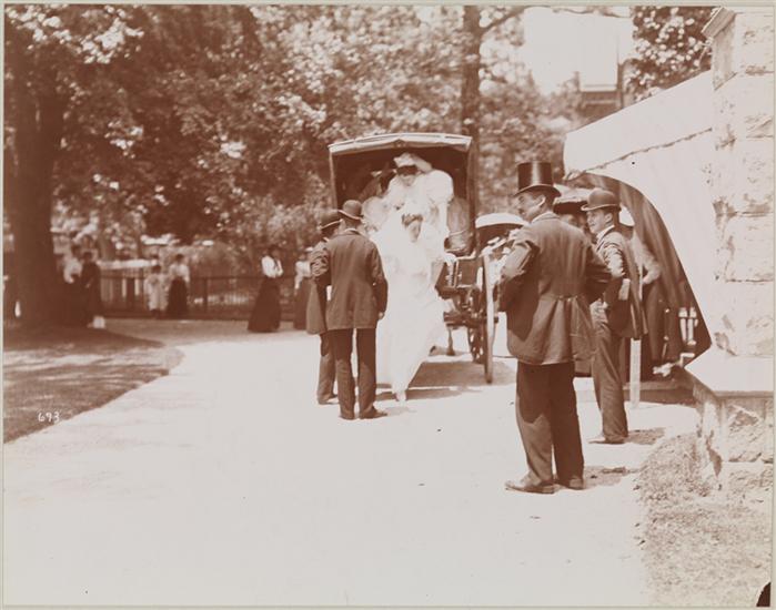
The Bride's Arrival at St. John's Episcopal Church
A little more digging turned up the following article from the New York Times on May 17, 1895. One of the things I've learned in digging into the history of Staten Island's golden age is that the very wealthy were very well documented.


Above - The Bride's Carriage Returns - Right - The church today
 The Bride's Departure
 Wedding Reception Photos - presumably this is at "Clifton Berley".
Further research told me that the couple divorced and both outlived their only son, George. Belmont ended up in the papers when he was sued by a widow for failing to live up to his promise to marry her. Mrs. Tiffany became a noted society decorator and decorate the Astor Estate on Bermuda. Later both ended up in the papers again when it seemed their son was arrested for drug addiction and committed to the Bloomingdale Hospital for the Insane.
New Link - The Museum of the City of New York
A new link to the right - the Museum of the City of New York. The assortment of Staten Island pictures is greatly limited but it is a nice selection of things I haven't seen before. Cool, and a generous tip of my hat to the lovely Mrs. B. for brining it to my attention.
Tuesday, December 21, 2010
Anson Phelps Stokes' Mansion

1928 - The Stokes Mansion two years prior to its demolition. A close look reveals a collapsing roof on the sun room in on the center first floor. There's a general look of abandoment to the place.
One of the most elaborate appearing mansions from Staten Island's Golden Age was that of Anson Phelps Stokes. It occupied part of the hillside land between Hamilton Avenue and St. Mark's Place and looked out over the harbor and New Jersey.
With architects, merchant bankers, Episcopal priest and whatnot in their family tree it would be interesting to see where the heirs of this once prominent family have ended up.
The family was clearly very devout, with Anson's grandfather helping to found the
London Missionary Society. Anson Stokes actively supported the American Bible Society, the American Tract Society and the American Peace Society. His son, Anson II, became an Episcopal priest and resident canon at the National Cathedral. His grandson, Anson III, also became an Episcopal priest and eventually the bishop of Episcopal Diocese of Massachusetts.
Caroline Phelps Stokes, one of Anson's sisters, left her estate to the form the Phelps Stokes Fund in order to help improve the housing and education of minorities. Later his other sister, Olivia, used the fund to specifically aid "Negro education". Nowhere on its website does it do more than acknowledge that it was founded by a bequest of Anson's sister Caroline. Her brother Anson and his son the Rev. Anson P. Stokes were both initial trustees of the fund. I wonder if any members of the family have anything to do with the fund at all anymore.

1928 - Same house different vantage point

1874 - The Stokes Mansion and Estate - The heyday of the Island's great estates. To the west is Ladislao de Escoriaza's estate and to
the east that of J.C Green, esq.

1917 - De Escoriza's and Green's mansions are gone, the latter replaced by Curtis High School.

2010 - The only reminder of the Stokes estate is Phelps Place.

1928 - Gate and gatehouse to the Stokes Estate - northside of Hamilton Avenue between Phelps and Egmont

1928 - Gate and gatehouse to the Stokes Estate - northside of Hamilton Avenue looking west from Egmont Place
Wednesday, December 01, 2010
Lost Streets and Homes

The Bayonne Bridge is one of the beautiful municipal structures that remain from a lost golden age. It drive past it several times a week and I'm never not caught by the bold curve of it arch in the day and the patriotic lighting in the night.
But, like many elements of the City's infrastructure its creation came at the cost of homes and pieces of neighborhoods. Going to the maps I set out to see what had vanished in the wake of the bridge's construction in 1928. While no whole heart of a neighborhood was destroyed like with the housing projects in Stapleton, West Brighton and New Brighton, it did result in a giant structure rising like a wall between Elm Park and Port Richmond.

1917 Map - someone helpfully penciled in the bridge's location. Douglas Street is gone and Newark Street half deleted and John Street cut into parts.


Bridge Stanchions Crossing Richmond Terrace
- l. 1931 (Dean Linseed Oil Works in the background)
r. 2010
Below - demolition on the south side of Innis Street - 1928
Bottom - roughly same location - 2010

View Larger Map
There are times when real public needs require drastic changes in landscape. This would seem to safely be one of those times. It never hurts, though, to remember that bridges and highways come at costs more than dollars.


Above - West side of Newark Avenue south of Richmond Terrace - 1928 and 2010
SPECIAL BONUS SHOT - Dean Linseed Oil Works seen from Bayonne

Subscribe to:
Posts (Atom)