Monday, December 28, 2009

A Neighborhood Far Afield


In the heart of downtown Los Angeles is the neighborhood of Bunker Hill. Once it was a steep hill covered with Victorian mansions and shops and reached by seemingly impossibly steep trains tracks.


Over time their wealthy owners moved to the suburbs in places like Pasadena and the mansions became apartments and flophouses. The whole area became a giant filming location for film noir movies.


In 1955 the city decided the neighborhood as is stood impeded the city's development. They declared it blighted (which of course once such a determination was made only led to area becoming truly blighted), eliminated the 150 foot height limit on new buildings, and leveled the district. Literally. About a hundred feet were shaved off the hill, tearing down most of the old buildings and making way for the steel and glass skyscrapers that dominate the downtown today.
I don't know anything about LA and I can't say much about the rightness or wrongness of what was done six decades ago. But I can provide a link to an amazing site ( On Bunker Hill) put together by local LA historians and aficionados in order to document the old, and long lost, Bunker Hill.

Saturday, December 26, 2009

MERRY CHRISTMAS!!!!!

As usual I've left things till too late, but, Merry Christmas to one and all!

Tuesday, December 08, 2009

Shults Bread Company and company

On Cary Avenue and Taylor Street in West New Brighton (edging perilously close to Port Richmond), stands an old factory built of red brick. In my time it's housed the Art Network (who remembers that now?) and then, in one form or another, a church for the last decade or so.

Apparently, formed from the consolidation of several bread wholesalers, for a few years the Shults Bread Co. was one of the most prolific bakeries in NYC. They operated a dozen factories in and around the city (six in Brooklyn, their home, alone). In 1923 they were acquired, in a stock deal, by the United Bakeries Corporation and were no more. UBC renamed itself Continental Bakeries, and became one of the biggest bakers in the country.


View Larger Map

I've posted this theater before, but here's it's in a larger neighborhood context. It was the first movie theater on Staten Island and until recently it maintained much of its original facade (see the googlemaps' picture) though its present Pentecostal owners have finally fixed up the building and covered it over.

The intersection of Castleton and Broadway and several blocks around seem to have been an entertainment nexus a century ago. There was an opera house (!) on Henderson and Broadway and a movie theater on the corner of Broadway and Noble. Now there's projects, dollar stores and scary delis.

Tell me again how were things improved when the projects replaced older working class apartments? Am I wrong in thinking that people aren't meant to live piled together in giant apartments like ants? How many people and neighborhoods suffered because Corbusier offered a cheap way out for packing in the poor like rats?


View Larger Map


View Larger Map

Thursday, December 03, 2009

An Industrial Bend in Richmond Terrace


View Larger Map

Taking Richmond Terrace westbound heading toward Mariner's Harbor and points beyond, at West New Brighton, right past Broadway, there's a great northward bend in the road. On a low rise on the south side of the road is an old factory building that is the beginning of an industrial and commercial area. Part of me always wondered what that factory made in the sooty days of its youth. Now I know (and you will too), thanks to my new found map friends.

It was the part of the C.W. Hunt Company. According to the NYPL website, the firm were "manufacturers of railway freight cars, coal handling equipment, and related machinery".


View Larger Map

This building appears to have been the boiler house. I assume it's where engine boilers were cast.


View Larger Map

These buildings were all part of the C.W. Hunt Co.'s factory once in a long ago past of red hot iron sparks and clanging machinery and coal dust.

Friday, November 27, 2009

The Block

This amazing project is something I happened across while doing my usual Staten Island research. He had a few now/then shots of SI posted and tooling around the rest of the site I found "The Block". It's a beautifully rendered and animated history of the buildings along a Manhattan block from 1795 to 1991.

Sunday, November 22, 2009

Big Houses on the Hills

Until about 1986, the property across the street from my family's home on Cebra Avenue was a high, tree covered hill with an old foundation and driveway hidden away in the overgrowth. Throughout my childhood ramblings across the wooded spaces of Staten Island I came across several old foundations. One was in the woods near my grandma's house on Henderson Avenue and another was several blocks from my Cebra home on Austin Place.
Going through the old survey maps on the NYPL's site I've discovered the names of the owners of these and similar houses and in some cases the names of the homes themselves. It's a great find and a fascinating look at Staten Island's old, wealthy past.

Cebra Avenue and Ward Avenue - Someone named Chester E. Clark owned the house across from mine and called it Hill Top. This map is from about 1917. By the time my family moved to Cebra in 1969 the house was long gone. Today all that remains is the man's name split into the names of two inconsequential little streets and about one hundred shoddy attached houses.


View Larger Map

Highview Avenue and East Buchanan Street - Taking a walk with the luminous Mrs. V. one day up Highview we spotted the foundation remnants shielded from the casual passerby by the trees covering the now houseless lot. Once a man named Thomas Bushell owned it. Now it's nothing.


Henderson Avenue and Bard Avenue - This house was two up from my grandma's house. I remember coming across the ruins and my grandfather telling me it was from a house that'd burned down some years ago. Today I can't tell who owned it and if it even had a name.


View Larger Map


Austin Place and Ward Avenue - This house stood on what had become a large wooded lot we hung out in all the time by time I was twelve years old. The Fredericks house was still standing, occupied by a scary old lady supposedly related to my friend Bruce N., until only a few years ago. It was finally torn down and the lot was covered with ugly attached houses and a series of plug ugly "mini mansions".

When I hung out there and played manhunt and other games, the basement of the Lederle house was still there sunk beneath the earth and covered with the old flooring. There was hole, probably from a stair case, you could climb down into. Rising up over the place the tennis courts had been once been was a great dark stone wall. The first time I saw it it was like finding a lost ruin from Middle Earth. The Austin woods were by far the most interesting "natural" place we ever found when we were kids.


View Larger Map

When I come across these lost houses and family names I think about how they got this way: torn down, forgotten and built over. Do these families exist anymore? Obviously they had money, but if they still exist, do they still have it? Did all these houses burn down while occupied or where they abandoned and succumbed to fire from lighting or arson? Where they simply torn down and the land sold off?
It's a sad thing to see a home that's become abandoned and forgotten. I wonder what happened there. How many games of catch were played on the lawns and hands of euchre in the drawing room? Did servants live on the grounds and were they well treated? What happened to the businesses the owners ran to make their money? I don't know and I doubt anyone else cares anymore.

Thursday, November 19, 2009

The Hills Around My House - Jones Woods and Nearby

These two maps show the area around where I live these days at Franklin and Prospect Avenues. These maps, which I've never looked at too closely before, are eye openers. Apparently, the hill looming over Brighton Avenue, containing what's called Jones Woods, is called that because it once was the grounds of the estate of one Shipley T. Jones. So far, all I've found out about him is his gardener wrote an article on dahlia raising and he attended a fundraiser for the old Staten Island Hospital. Again, the lost history of the island is lurking everywhere.


The Cedars - Clearly, this estate was huge. It ran from Prospect to Brighton and from roughly Sumner to Harvard. Most of the property remains unbuilt on to this day and serves as a track for intrepid dirtbikers.


View Larger Map

S.R.Smith Infirmary - The core of the old Staten Island Hospital.


I've written and posted photos of this now crumbling place several times. It still holds a place in my heart and its current state and presumed future brings at least a nominal tear to my eye. The folks at the Kingston Lounge have a nice photo collection of the present state of the Infirmary's interior.


Richmond Rail Road & Light Co. Car House - Jersey Street and Victory Blvd. I'd always heard that the NYC Sanitation Garage had been some sort of machine shop in the past. Well, the map lets us know it was a garage for rail cars (presumably trolleys). You can even see the tracks running north up Jersey Street and west up Castleton Avenue.


From this overhead shot you can sort of see the footprint of the original building that's been added to over the decades by Sanitation.


View Larger Map


Borden's Condensed Milk Co. - Once upon a time, when Jersey Street was a flourishing commercial and industrial avenue, Elsie the Cow held sway over a factory turning out condensed milk for all the households. Now, sadly, both Borden's and the factory are no more. Elsie still lingers on but in a severely limited state.


View Larger Map

Tuesday, November 17, 2009

Vertical Staten Island


Stairs on Benziger Avenue in New Brighton

I happened across a beautiful collection of North Shore hills and staircases at something called Walking Is Transportation
. Check out some beautiful pictures of some of the most out-of-time locations on the North Shore. And also see what can be accomplished when you get off your fat rumpus and actually venture forth and take pictures with a camera instead of just snatching stuff off the web and Google.

Victory Blvd. stairs entrance

View Larger Map
Here's my own sad little contribution to the catalog of North Shore staircases. These stairs climb up the back of the hill Tompkins Circle sits on up to said street.

Tompkins Circle entrance


View Larger Map

Thursday, November 12, 2009

Forest Avenue in Ole Tymes and Now


View Larger Map

Running parallel to Castleton Avenue for much of its generally east-west run, Forest Avenue is tied with Victory Blvd as the North Shore's most important commercial avenue. Starting at the crest of Victory Blvd.'s first great hill, Forest Ave. starts alongside Silver Lake Park and Golf Course. It then cuts its way through the southern portion of West New Brighton. The stretch between Oakwood and Bement used to be called Peter Pan Alley because it was lined with Irish bars; the denizens were green and never grew up.
West New Brighton runs roughly from Hart Blvd to Jewett Avenue. From Jewett to Richmond Avenue Forest cuts Port Richmond off from Westerleigh and Willowbrook. At Richmond Avenue it separates Elm Park and Mariner's Harbor to its north from Graniteville before coming to an end in the marshlands of Bloomfield.

The first lovely house was located on the north east corner of Oxford Place and Forest. Today it's a series of relatively unpleasant townhouses thrown up in the 90s. The second house is still standing on a beautiful block between Oxford and Duer Lane opposite Silver Lake Park.

Silver Lake - Oxford and Forest


Silver Lake - Forest and Duer - This house was owned by Louis A. Dreyfus, a noted chewing gum magnate and Staten Island civic activist. He and his wife donated the land for Hero Park and supported numerous churches, schools and charities. IS 49 in Stapleton is named for his wife, Bertha.


View Larger Map

Today the intersection of Forest and Bard is a major commercial area with a Keyfood, drycleaners, a Starbucks and a CVS. Once upon a time it was a fairly sleepy (and dusty apparently) crossroads.

West N. Brighton - north side of intersection looking east along Forest Avenue


View Larger Map

I had to blow up the bus just because I thinks its pretty nifty looking.


On the south side of the intersection is Our Savior Lutheran Church. I've mentioned in an earlier post how it was once the church in the basement. Well, here's proof.


View Larger Map


West N. Brighton - Forest and Clove Road - This beautiful estate was owned by the Brooks family (who I have no idea who they were) and was called, imaginatively, Brooklawn) Today it's all gone and been replaced with the northern stretch of Clove Lake Park.


Graniteville - Richmond Avenue between Forest Avenue and Monsey Place - Today Monsey doesn't even intersect with Richmond and there's a filthy gas station and convenience store on the spot. Good going, people.


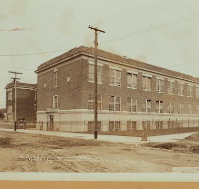
Graniteville - PS 22 - Forest and Columbus Street (well, today, Columbus doesn't even exist and a new extension to the school's been built across its roadbed) - This picture from the early 30's shows the "new" extension built to the original school on the picture's left. Today another extension has been attached to this extension.


View Larger Map

Thursday, November 05, 2009

Castleton Avenue in Olden Tymes

Castleton Avenue is one of the major thoroughfares of the North Shore. It stars in New Brighton near the south terminus of Jersey Street, rises up into Silver Lake, winding its way past the old Staten Island Hospital and into West New Brighton and past the old St. Vincent's Hospital (now, boringly, called Richmond University Medical Center). It continues through West New Brighton passing the Civil Court House, Calvary Presbyterian, Sacred Heat R.C. Church, the West Brighton Projects and on towards Port Richmond. It finally ends, after having run past the Castleton Bus Depot and crossed the crumbling commercial center at Port Richmond Avenue, at Nicholas Avenue near Port Richmond High School.

southside of Castleton between Pelton and Oakland - This first building was once the West New Brighton sub-branch for the New York Public Library. For as long as I can remember it's been a junk shop.


View Larger Map

southwest corner of Castleton and North Burgher - Today the West Brighton Branch of the New York Public Library sits here in its stately Carnegie building.


View Larger Map


View Larger Map

You can see the original steeple of Sacred Heart that was lost to fire many decades ago.


southwest corner of Castleton and Caroline - Half the building was occupied by a James Butler Store. Apparently that was a successful chain of stores at some time in the past. Twenty years ago the building was used by a local civil rights organization called "Heritage House". Until fairly recently you could still see their signs on the place. Back then I worked at NYS Parks, Recreation and Historical Preservation. The group was getting state dollars to turn the building into a state of the art community center. I don't remember the specifics but there were problems with the group's handling of the renovation of the building and in the end the project fell apart. Now I think it's got the dreaded X for condemned on it.


View Larger Map


northwest corner of Castleton and Port Richmond Avenues - once in the dim, and distant past, Port Richmond was a major commercial center. Even in the days of my youth it was a beacon for North Shore consumers. There was a Woolworths and several other similar five & dimes. There were restaurants, clothing stores, photographers, and all other manner of shopping destinations. Then the Forest Avenue Shoppers Town came into being in the late 60's followed by the Staten Island Mall in 1975. Within a few years the stores began losing customers in droves and closing up shop. There was an effort at a commercial revival in the 80's with an emphasis on furniture stores but this was enough.

With the arrival of large numbers of Mexican laborers in the 90's (to do work that Staten Islanders might have to pay someone else a decent wage to or, heaven forbid, do themselves) the neighborhood became a very different place. Now, many of the old, vacant stores have been replaced with restaurants and discount stores selling Mexican products. Unfortunately this new Port Richmond remains as bedraggled and rundown as it did when the old businesses first closed up shop in the 70's.


View Larger Map

Thursday, October 29, 2009

Staten Island Ferry


The Staten Island Ferry has its roots in private sailing vessels used to connect the island to the rest of the region going back to colonial days. In the early 19th century, Daniel Tompkins established the Richmond Turnpike Company in a effort to develop the town of Tompkinsville on the North Shore of Staten Island. He started a commercial service that later introduced the first motorized steam ship in 1817. This line was later bought by Cornelius Vanderbilt. Eventually he sold his ferry service to his brother and finally it ended up in the hands of the B & O Railroad. Following a major disaster when the ferry Westfield exploded in 1871 (killing nearly 100) and the Northfield being sunk in 1901 (with 5 dead) the city seized control of the Staten Island Ferry system.

Since the city took over it's been nothing but unicorns and butterflies. Well, not really. There have been collisions, seawall rammings, and, most notably, the 2003 dock collision that left eleven dead, and crippling several. Miraculously, though the pilot went to jail but the captain, though responsible, escaped jail time, essentially because the Dept. of Transportation had never enforced its own guidelines about how a ferry should be crewed during docking. As usual with the Bloomberg administration, no real high ranking employees of the department responsible for the ferry's mismanagement were even disciplined (see FDNY and the Deutsche Bank fire).

As a Staten Islander the ferry has been a major part of my life since I was very small. Only in the past seven years have I stopped riding it with any sort of regularity. Before that, like tens of thousands of other Islanders, I rode it ten to twelve times a week. It formed a crucial part of my memories of childhood trips to museums, plays and shopping trips. As I grew up it became part of my daily school and work trips.

The new terminal, stark and silvery stands in tremendous contrast to the ugly functional industrial style terminal I grew up with and in even greater contrast to the beautiful and ornate one built by Carrere and Hastings. That one burned down in 1946.


From the pictures I've been able to obtain it was clearly beautiful. I sort of wish my memories were of that lost edifice instead of the ugly, bolt covered thing that too often reeked of urine and pigeon droppings.


Thursday, October 22, 2009

Borough Hall


Whatever one might think of the job of borough president (I think as the only borough wide elected city official I think, even shorn of power, it's they're valuable representatives for the boroughs), Staten Island's has one beautiful borough hall to work out of. It was designed John Carrere and Thomas Hasting, and is one of the finest works of municipal architecture in a city filled with beautiful municipal constructions. Borough Hall and the nearby courthouse, along with the long ago burned down ferry terminal, were the three completed elements of a planned mall along Richmond Terrace. It would have also included a federal building, a post office and a museum. Still, they did design the St. George Library. Sadly it's been destroyed as a good library on the inside but it remains a striking element of the St. George skyline.


View Larger Map

The center building was originally the Corn Exchange. When I was little it was the Chemical Bank branch my parents used when we lived on Stuyvesant Place before moving to Stapleton. It had a huge numeric clock made of lightbulbs on its roof that you'd watch coming in on the ferry.

Saturday, October 17, 2009

The other remaining Methodists

Summerfield Methodist Church - 104 Harbor Road - Mariners' Harbor


View Larger Map


Christ United Methodist Church - 1890 Forest Avenue - Graniteville


View Larger Map


I did a little mucking around on the United Methodist Church's website to see what I could discern about Methodism on the Island. The numerous remaining churches (there are several more on the South Shore) are all barely hanging on with tiny congregations (except two of the Korean congregations). If you go to the other boroughs there are huge congregations. So I still don't have my answers and I continue to be intrigued.

Friday, October 09, 2009

I Really, Really Want to Go Home Now.

I'm actually embarrassed to be Swedish and American this morning. Now, don't get me too wrong, I think Obama's a sort of okay person. As a president he's been okay too, though only because he's turned out to be so utterly incompetent that the woefully awful and economy-threatening things he's talked about he can't get implemented. I say this because my libertarian tendencies are satisfied by a president who can do less and less to interfere with the daily lives of Americans.

What I don't like about Obama is his crawling on the world stage and making nothing but abject apologies for the 'crimes' and missteps of the United States. I don't like that he's supported Zelayas in Honduras. I really don't like that he blew off the Dalai Lama in order to make kissy face with the Chinese.

So now this: the Nobel Peace Prize. It's really been an absurd award since they gave it to Al Gore for fighting global warming and Jimmy Carter for hating George Bush (no, wait it was for finding "peaceful solutions to international conflicts, to advance democracy and human rights, and to promote economic and social development").

Barak Obama may yet go down as the greatest president of all time. I'm being serious for a second. Right now he isn't. He's a man with barely enough qualifications to be president who's been in office for nine months and not really accomplished anything. I mean nothing in the most objective and nicest possible way.

Now I feel like I'm taking crazy pills. All those creepy instances of school kids singing his praises in the last few weeks or that "pledge" video are starting to make me feel like I must be wrong. Maybe he's already greater than Washington/Jefferson/Lincoln combined. Maybe he will lead us to a greater tomorrow. Maybe.

Maybe I just need to go home, curl up under the blankets, pull the pillows over my head and hide out for the next three years.

Tuesday, October 06, 2009

Methodism, wherefore art thou?

I've written before about something I call 'the Great Methodist Collapse". I still don't know anything about what happened to the Methodist churches on Staten Island in the late sixties but of the six churches (and one chapel) I know of on the North Shore, three of them closed and were sold off to other parties. Presumably it was a combination of the demographic changes (though the late sixties seems too early for that) and the general decline in urban mainline Protestant church attendance (and, again, there's a problem in that the Methodist church stayed strong through today). Someday I'll actually talk to a Methodist church historian and understand what happened. Just not today.

Faith United Methodist Church - 221 Heberton Avenue - Port Richmond


View Larger Map


The link leads to a detailed history of the birth of United Methodist Church from a combining of Grace Methodist Church (the present United church) with Kingsley Methodist in Stapleton and Trinity Methodist in West New Brighton.

Thursday, October 01, 2009

The Reformed Churches

Once upon a time Staten Island was a Dutch settlement. Today that's mainly recalled by the existence of Dutch or Netherlands related street names (Stuyvesant Pl., Brabant, Walloon, Van Pelt, Van Name, etc.). Another bit of remaining history though are the few remaining Reformed congregations. Until the mid-80's the Reformed Church in America (RCA) was known as the Dutch Reformed Church. Demographics and history I imagine caused them to ditch the Dutch.
At present the VP of the RCA is the Rev. James Seawood, pastor of Brighton Heights Reformed Church in St. George. Next year he becomes the president. Good man, good pastor and nice guy.

Brighton Heights Reformed Church - 320 St. Mark's Place - St. George


View Larger Map

This congregation was founded around 1827 as a offshoot of the ministry established at the Quarantine Station in St. George by the minister of the Dutch Reformed Church in Port Richmond. The old building constructed in the late 19th century was destroyed by fire during renovations in the mid-1990's. The new building was dedicated in the last decade.


Reformed Church on Staten Island - 54 Port Richmond Avenue - Port Richmond


View Larger Map


This is one of the oldest churches on Staten Island and one of the oldest congregations (beat only, I think, by St. Andrew's Episcopal in Richmondtown). It was founded by Belgian Huguenots and later became part of the Dutch Reformed Church. The original church was burned down during the Revolution by the British and the new one erected in the late 18th century. There's an attached graveyard with 17th century headstones (and bodies presumably). Apparently it's a small and dwindling congregation but the Staten Island Preservation League's housed there so they've got that going for them.


There used to be at least one other Dutch Reformed church on the North Shore. Appropriately enough it was located in Mariners' Harbor which has the largest concentration of Dutch names (Holland, Netherland, Brabant, Mesereau, etc.). Near as I can determine it closed in the late sixties. At present the old church is home to Fellowship Baptist Church.

Mariners' Harbor Dutch Reformed Chapel - 3036 Richmond Terrace - Mariners' Harbor


View Larger Map