Wednesday, November 07, 2012

Exciting News!

   In 1930, William T. Davis and Charles W. Leng, co-founders of the Staten Island Institute of Arts & Sciences, published their five volume "Staten Island and Its People: A History 1609-1929".  For anyone interested in the past of this borough this is an incredibly important work.  Until now I've been forced to copy notes out of the library copies at CSI.  My ability to simply leaf through to my heart's content has been limited at best.
   Last year I went to an estate sale in hopes of buying a set but was confronted by a price that was above my limits.  Now, however, a more attainable set has appeared on my horizons.  At present they are being prepared to wing their way down from the Great White North (well, at least Nova Scotia) into my living room and onto my bookshelves.  To say I'm excited is way too much of an understatement.


   I hope it means a return to regular posting for this site.  I've hit a bit of a wall regarding new stuff.  Mostly it's because of my recurring laziness and not making myself go to the St. George Library.  With these in my hands I should have a surfeit of new material to write about.  Here's hoping.

Tuesday, November 06, 2012

Long Live Stasis!

   Well, looks like it's all done for another four years and I can stop obsessing about things I really can't do much about and I'm pretty grateful for that.  Now I can get back to blogging about Staten Island, S&S and trying to write more.  Woo hoo!

Friday, November 02, 2012

Hurricane Sandy

  Fortunately, my wife and I survived Hurricane Sandy with power intact.  Though less than half a mile from the waterfront we live 186' above sea level.  If we ever flood the world's done for.
   My sister-in-law, her husband and their four boys (all under 8) are at present living with us, refugees from their blacked out New Jersey home.  Around us, where power was out mostly due to the great number of downed trees, is slowly being restored.  We feel inordinately blessed and secure.  I hope and pray anyone whose suffered is able to find assistance.
  So right now I'm cooking for eight, reading crime books and watching to see what we can do to help once the immediate problems (broken gas lines, downed power cables) are addressed.  I know my church has power and will be doing all it can.  I actually trust the local politicians (from Staten Island, not citywide, ie. the mayor) to work hard to ensure the borough's not forgotten in the shadows of New Jersey and Manhattan.
  It's going to be be a rough time and I suspect many of the destroyed houses will not be rebuilt.  I also don't trust a mayor whose idea of an appropriate response to such devastation is to hold the NYC Marathon to do well by the borough.  As NYC is a cesspit of corruption, I also don't hold out a lot of hope for FEMA money to be spent well if the city gets it hands on it.  
   These look to be parlous times for my beloved Rock.  When the bridges were all closed Monday I was reminded I live on a island and can be trapped here.  Coupled with the strain on resources caused by population (and the mayor wants another million people to come here), constricted transportation corridors and crumbling infrastructure, I can really see the day coming, sooner rather than later, when pack up and leave.  I don't even know if I'll be sad on that day.

Friday, October 05, 2012

Go See the Sights

   Reading SI Live this morning I came across this great bit of news. Tomorrow numerous historic Island places will be open for tours.  It's part of a citywide event sponsored by the Historic House Trust of New York City.
   While the usual suspects (Alice Austen, Snug Harbor, Conference House, etc) will be open, so will places like Port Richmond Reform Church and Christ Church on Franklin Avenue.  Fortunately the tours will continue on Sunday.  So, while I have to work tomorrow, I can go the following day.  Go check some of these places out.  Maybe I'll see you there.


Thursday, September 13, 2012

From Farms to City - Museum of the City of New York

   For the next several months, the Museum of the City of New York, located at 1220 Fifth Avenue and 103rd St in Manhattan, will present  an exhibit dedicated to Staten Island.  Called "From Farm to City: 1661 to 2012", the exhibit will run from Sept. 13 to January 21.  Curated by Liz McEnaney and presented in association with the usual Island suspects (SI Historical Society, Richmondtown and the SI Museum), it looks to be an examination of the Island's evolution from rural to suburban and ultimately heavily urbanized environment over the past three and half centuries.
   I'm really looking forward to seeing what insights a non-Islander makes into our hermetic little borough.  Too often the focus of Staten Island historians seems to be on the big touchstones (Alice Austen, Farm Colony, Richmondtown, Conference House, etc.) again and again and again.  Fresh eyes are bound to see things we ourselves don't notice.
   The museum has also set up an exciting extra: interactive maps.  They've presented all the various historical maps of the Island going back to 1750.  You can look at a modern day map and then overlay the historical one of you choice and see how things have changed (just like I've been doing for sometime now).  Where I'm particularly jealous is where they've made complete composites of all the separate pages from the various maps.  Absolutely amazing and I'm so grateful to the Museum for doing this and making it available for all to see.
 

Thursday, August 30, 2012

Fox Hills' Magnificent Past

   Fox Hills, a portion of Clifton, was once a prosperous place of large homes, a golf course and open fields.  In 1860, according to the NY Times, a great convocation of Republicans gathered at Clifton Park's Pagoda to hear speeches by George Curtis and Horace Greeley in support of ratifying the presidential nomination, Abraham Lincoln.  I'm not exactly sure where the Pagoda was but my research leads me to believe it's described as being at "the head of Simonson Avenue" which means at either Bay Street and Greenfield Avenue or where Osgood and Greenfield would theoretically intersect.


   Today  it's seen mostly as an appendix to the neighborhood of Park Hill and suffers from the same poor reputation.  Driving through, it should be clear that even after residential development did away with its open spaces it was still a comfortable middle-class place of comfortable and attractive homes.


The estate of Mr. J. D. Dix over the ages


   The house slowly lost its open surroundings and looks to have been demolished sometime between 1951 and 1971.  That's the date, and I offer no guarantee  as to its accuracy (the C of O is dated March, 1975), given by NYC's online records for the thirty-unit apartment building built where it once stood.  The one reference I found to Mr. Dix was about his house being used in the 1850's as the meeting place of the founders of the late First Presbyterian Church.  

   Fox Hills was originally the name of one Lewis Henry Meyer's estate.  Later a golf course sat where the bulk of the Fox Hills and Park Hills apartment complexes now loom.  The course was originally laid out by the Staten Island Cricket Club in 1899.  When the club went bankrupt about a year later the Fox Hills Golf Club was founded by men described by the NY Times as "enthusiasts" in order to save the links for golfing.  Unfortunately the plan only lasted until 1935 when the Depression killed the club closed.
   According to NYC Park's page on the playground at Sobel Court, an army hospital was built along Vanderbilt Avenue in 1918 that operated until 1922.  It was reopened as a hospital and POW camp during WW II and after the war converted to veterans housing.  In the fifties the military closed the site for good.
 

The Fox Hills Base from somewhere around Van Duzer or Targee Street I'd guess.

   Today the only clear reminder of the area's golfing past is Fairway Avenue.  The club house stood about where Osgood and Fairway Avenues meet.  About where it stood is now occupied by the Ukrainian Church and houses.


    left - Fox Hills Golf Course Club House     right - Fairway and Osgood Avenues (from Google)

   So there's an initial taste of the wonders of old Fox Hills.  So far I haven't been able to find any of the houses in the foreground of the base picture but I'm sure some are still extant.  Maybe by the time I do my next post on the area I'll have found them.  Here's hoping!


Sunday, August 19, 2012

Post and Jewett - the Rector Street Interceptor

   According to some random website I found, a sewer interceptor is one that "in a combined system, control(s) the flow of sewage to the treatment plant. In a storm, they allow some of the sewage to flow directly into a receiving stream, thus keeping it from overflowing onto the streets. Also used in separate systems to collect the flows from main and trunk sewers and carry them to treatment points."  Apparently, there's one referred to as the "Rector Street Interceptor" that flows under the intersection of Jewett and Post Avenues.  In 1955 the NYC Dept. of Public Works took some nice shots of the intersection.


Eastern Corners


Southwestern Corner


   It's fascinating to see that while still a commercial hub, it pales in comparison to what it used to be.  It was actually busy enough to warrant its own NYC crossing guard.  Can you imagine that today?
   There are some pictures I have of adjacent buildings that have been converted from storefronts to apartments.  I imagine the death brought to Richmond Avenue (in Port Richmond) by the Plaza contributed to the death of such small shopping districts all over the North Shore in the late sixties and early seventies.


Sunday, August 05, 2012

Doctor Elliott's Amazing House - Delafield Place


  I've written a little bit about Dr. Samuel Mackenzie Elliott before.  What I've never written about ('cause I didn't realize what it was) was his home which still stands on Delafield Place opposite Walker Park.

 According to the late Dorothy Valentine Smith in "Staten Island: Gateway to New York", he came here in 1836 when he bought several acres of land.  Over time he became one of the nation's preeminent oculists, attracting such prominent patients as Gen. Winfield Scott and Francis Parkman.  He also constructed between twenty and thirty beautiful homes.  Some, which I've written about, still remain, including the one next to his own large home.

   Several of his wealthy patients found themselves attracted to Staten Island's beauty and nearness to Manhattan and remained as residents.  Among these were the Shaws, known to most folks, unfortunately, only from "Glory".  Another was writer George William Curtis who famously said "God might have made a more beautiful place than Staten Island, but He never did".  

   These people formed the heart of the liberal, Unitarian community that made up an important part of the Island's culture in the mid to late 19th century.  The Shaws lived in a huge house that once occupied the corner of Davis Avenue and the Terrace.  Mr. Curtis' house, still standing in very good order, is at the corner of Henderson and Bard Avenues.  
   Doctor Elliott, while an ardent abolitionist and ally of people like the Shaws and Curtis, was no Unitarian.  On his property he built a small Episcopalian chapel and secured it a rector.  Over time it became too small for the congregation and the existing St. Mary's church was built as a replacement.


   Here we see Dr. Elliot's own home on the usual 1874 map.  The property stretched down to the waterfront.  The house actually faced in that direction, its present entrance on Delafield Place being  the original rear.  One only has to see the mighty Doric columned doorway to see that.  I would love to see what the front grounds looked like in their original state.  


    By 1917 the whole neighborhood was changed.  Part of the Delafield Estate had been given over to the Staten Island Cricket and Tennis Grounds.  The Neptune and Hesper Rowing Association's cove in the Kill van Kull the has been filled in, the railroad's been built (the old Livingston mansion turned into a station) and the Richmond Light and RR Co. built a powerhouse over it.  The big estates are starting to be broken up.           


   I've frequented the Livingston neighborhood for my entire life.  My mother grew up on Henderson between Davis and Bard and I spent my summers there with my grandmother.  Walker Park was place my mother took me and my sister to all the time.  I never realized the size and importance to the Island's history of this house tucked away behind tall trees and thick hedges on Delafield Place .  Only attending an estate sale there recently did I discover the great entrance hidden at its "rear".  Inside it is a great, sprawling place that must have once been afforded a stunning view of the Kull and the green shores of New Jersey.
   The owners, now retired and looking to sell the house, are hoping to sell it to someone who will pamper it and maintain it as it deserves.  I hope so too.                         

Tuesday, July 17, 2012

Jon Lord - RIP

There are so many things about Deep Purple I love.  Jon Lord's organ playing was easily one of the most important and distinctive parts of the band's sound.  Rest in peace.

Forest Avenue


   Sorry I've been so lax here for the longest time.  I'm going to try to get back in the saddle and all that jazz and start writing/posting again.  Here's an appetizer - Forest Avenue, 1917 from Greenwood Avenue all the way west to Bement Avenue.
   It's a pretty amazing transformation over the past century.  In the east there's the south extent of Sailors' Snug Harbor.  Hart Boulevard running north from Forest served essentially as an entrance road.  Now it's lined with houses.
   The lot where the Starbucks sits at Bard and Forest (and before that, the much missed standalone Carvel Ice Cream - I like the iconic design much better than the same as everybody else storefront of present day Carvels) was the property and large home of one "H. O. Rambout".  Most noticeably, though, was the absence of much housing at all.  Most of that stretch of Forest, long a commercial hub, was tree lined and sparsely populated.  Hard to imagine - if I didn't have the picture below you might just find it impossible.


Intersection of Bard and Forest Avenues

Wednesday, July 04, 2012

Happy Independence Day!


   We weren't perfect then and we aren't perfect now.  Along the way from then to now a lot of blood's been shed and often in ignoble circumstances.  Nonetheless, we've done great things, overcome deep and dark flaws, and are ever moving forward bettering ourselves.  For that, thank God.  Some days I think we've still got  a long way to go, but on most I'm just grateful for the actions take over two centuries ago that officially pushed this country into existence.

Saturday, June 09, 2012

Stapleton's Chinese Restaurants

   Last year I posted pictures of the Chinese restaurant that used to be up on the second floor of a building near the old Woolworth's on Water Street in Stapleton. I only went there once when I was a little kid. The places I went to as a teenager and adult were Ying Wah and Tung Bo. Now, thanks to the city's absolutely amazing gallery of tax pictures from the mid to late 80s, here they are in gloriously, grainy color.


This is the place I went to the most, first with my mom and sister (my dad hated anything that could be even vaguely label ethnic food) and later with friends.  Fairly generic as I remember but pleasant enough and nice staff.  As I older I came to appreciate their wide selection of ridiculous rum drinks in tiki head mugs.


   This seems to have been the older, more established of the two restaurants.  It was definitely a better establishment with better food.  Good memories.

Saturday, April 28, 2012

Vote for $$$ for Historical Preservation and Restoration


   Vote for Rossville AME at www.partnersinpreservation.com to get this nationally important church grant dollars. Part of Historic Sandy Ground, this church was built in 1897.

  If you don't want to vote for a South Shore site, vote for Our Lady of Mount Carmel Shrine over in Rosebank.  These two sites are small, underfunded and not on the radar for the big bucks like some of the more well known institutional sites on the Island.  Any help they can get will, I imagine, be greatly appreciated.


Thursday, April 19, 2012

Farewell to a Southern Gentleman - Levon Helm, RIP

  So passes the last of the Band's trio of vocalists (Richard Manuel in 1986 and Rick Danko in 1999) and the only American in such an American sounding and rooted group.  The Band is one of greatest artifacts from the sixties and produced some of the best music in that era and which stands up under the weight of time and changing tastes much better than so many more fashionable artists' work.  Taking from the pre-rock and roll sounds of America such as folk, country, blues and blue grass as well as early popular music, they embedded it in rock and made it even better.  I may never need to hear "The Weight", "Up On Cripple Creek" or "The Night They Drove Old Dixie Down" again, but to miss out on "Ophelia", "Chest Fever", "King Harvest" and so many others would be painful.

Glorious Broad Street - Stapleton Again

   The commercial heart of Stapleton is always assumed to be located at Canal and Water Streets along Tappen Park.  Well that's probably accurate it neglects the stores that ran from Wright Street all the way up Broad Street to Van Duzer Street.  According to my map reading skills that's about 1/2 a mile.  Add to that Broad Street from Bay to Tompkins and you get another 1/4 of a mile.  There half of the latter was pretty much residential, but still, that's about a mile's worth of stores catering to the needs and desires of Stapleton's citizens.  Once you add in the Tappen Park surrounds and Bay Street, Stapleton probably had at least as much commercial property as Port Richmond did.  Now much is gone or pretty low rent stuff.  So it goes.


291,293 and 297 Broad Street at the corner of Targee - 1931


When I was a kid the building on the left housed a canine patrol.  Its logo was a snarling dog's head.  My sister's dance school was originally in the same building on the Targee Street side.  It was called "Charing's Dance School" (or something very similar)


                                            Broad and Targee, northwest corner - 1931


Same corner today - It was an empty lot even when I was a kid in the mid seventies - I remember doing a cleanup of it when I was in the Weblos or Boy Scouts which would have been around 1977.


Broad Street, east from Gordon Street - 1931


Today - the corner store was candy store with a soda fountain when I was kid.  I only went once or twice but my mom and sister went there a bunch when she went to dance classes.


Broad, Canal and Tompkins - 1931


Today - Back in the early nineties the pizzeria (and as long as I can remember the building in the foreground has housed one) was called "Two Crusts".  I don't get why but it did make us laugh when we ordered and they picked up the phone and said it.


Bonus Picture:  Cop contemplating the world - 1931

Tuesday, April 03, 2012

Stapleton: Part One - Remembering and Ranting

   For over thirty years Stapleton was my home.  For all sorts of reasons my life revolved around the neighborhood.  My mom would go shopping in Stapleton every week and we'd eat lunch at the Woolworth's luncheon counter.  I went to the late school at Trinity Lutheran and my first on-the-books job was at the Stapleton Public Library.  
   My mother was intimately involved in trying to stave off the ultimate decline of Stapleton through a variety of community groups.  She helped found something called the Friends of Stapleton Library but in the end the use of volunteers was limited by the employees union.  Then she and the late Helen Pose, among others, invigorated the Stapleton Civic Association.  That led to large, annual  festivals and flea markets around Tappen Park.
   Finally she launched the Stapleton LDC and was its first director.  With a staff of three the LDC operated out of Stapleton Village Hall and secured grants for development and struggled to work with the merchants to preserve and encourage commerce in the town.  They got the Village Hall refurbished and the gazebo and brick work installed.
   All through this period there were lots people taking chances on businesses (ex. Cana's on Broad Street) and buying old homes and renovating them.  People like Addison Branch and Cynthia Mailman reminded people of the beauty of Stapleton's architecture.  Mud Lane was launched in 1977.  The great and definitely not late Norma Herz (superstar children's librarian) brought Peter Seger and the Clearwater to the town on regular visits.  There really seemed like some sort of renaissance was happening.
   In the end it all sort of came to nothing.  Over time the older businesses vanished (think John's Bargain Store, Store of A Million Items, the Army & Navy Stores, etc.) and the new didn't last or were more low end.  The SI Mall helped drive a stake through the heart of Stapleton's shopping district just as it did Port Richmond's.  But I think the greatest blow to Stapleton was its turning from a working and middle class neighborhood to a disproportionately poor one.
   I just read the Mud Lane Society's history of the decline of Stapleton and it's a fascinating bit of myopia.  They make it sound like only the blind eye of bad business killed Stapleton.  They claim, though vacant for 13 years, the Piels Brewery could have been turned to some sort of "adaptive reuse" without providing any examples.  They claim the Homeport only brought bars without noting that the base never became fully operational and filled with staff and families housed in nearby neighborhoods. High taxes, weak policing and changing economic demographics weren't the culprits according to them, or at least don't merit a mention.
   Most importantly they never comment on the Stapleton Housing Projects.  Once the City decided to focus on housing for welfare recipients instead of working class and municipal workers Stapleton started on a downward spiral it's never recovered from.  Yes, many of the white residents fled because of the appearance of black residents.  There's no denying the racism contained in white flight (if you read the SILIVE forums about Stapleton and took a shot at every racist comment regarding how great the neighborhood was you'd kill yourself) but it also holds an element of opposition to one's neighborhood being suddenly changed by influences out of your control.  The economic circumstances are different, surely, but look at the reaction of long time residents in Harlem and Bushwick to gentrification.  
   Still, the problem with housing projects is that they lock an area into a permanent economic stratum.  If you deliberately choose to make it the lowest economic one then there's going to be an effect.  It's the government saying "This will now be a poor neighborhood forever".


The block bounded by Canal, Cedar, Boyd and Wright - 1917


   As the middle-class consumer base that existed for the stores that ran from the top of Broad Street and Van Duzer all the way to Bay Street, along Bay and up Canal and Water Streets shrank the businesses suffered.  In the eighties and early nineties drugs and crime helped kill off many that had straggled on by scaring away customers.  Do you remember the last time you chose to go to the late Gelgisser's Hardware or Miller Drugs?
   Today crime is a much decreased part life in Stapleton (thanks to Giuliani, Bratton and Bloomberg).  Even though Woolworth's closed in 1997 (I think), the building has been occupied by the OZ Clothing since about the same time.  Other shops appear to be thriving.  Security helps lead to economic stability which leads to permanence.  Maybe the businesses on Broad Street and along Tappen Park will remain.  Maybe future Staten Islanders will be willing to continue taking a risk on Stapleton.  Still, it's not enough and old commercial and residential buildings will continue to rot away.


Right to Left - The Rex Theater and neighboring buildings - 1936


Today it's a nearly empty stretch of grass and trees and the brick sidewalk that were supposed to presage a better tomorrow


Previously the Rex had been the Park Theater - co of Wright and Canal - 1930


Intrepid Development's refurbishing of the old Ross Cosmetics building (I can't remember what was in it before except for Golden Cue Pool Hall {and does anyone have a picture of their old advertisment?} and Wright Toy & Hobby used to be in the back)


172, 176 and 180 Canal Street - 1932 - The brick building at the center is the Baker School of Business - It's not on the 1917 map and 172 is no longer there today.


Same as above - today


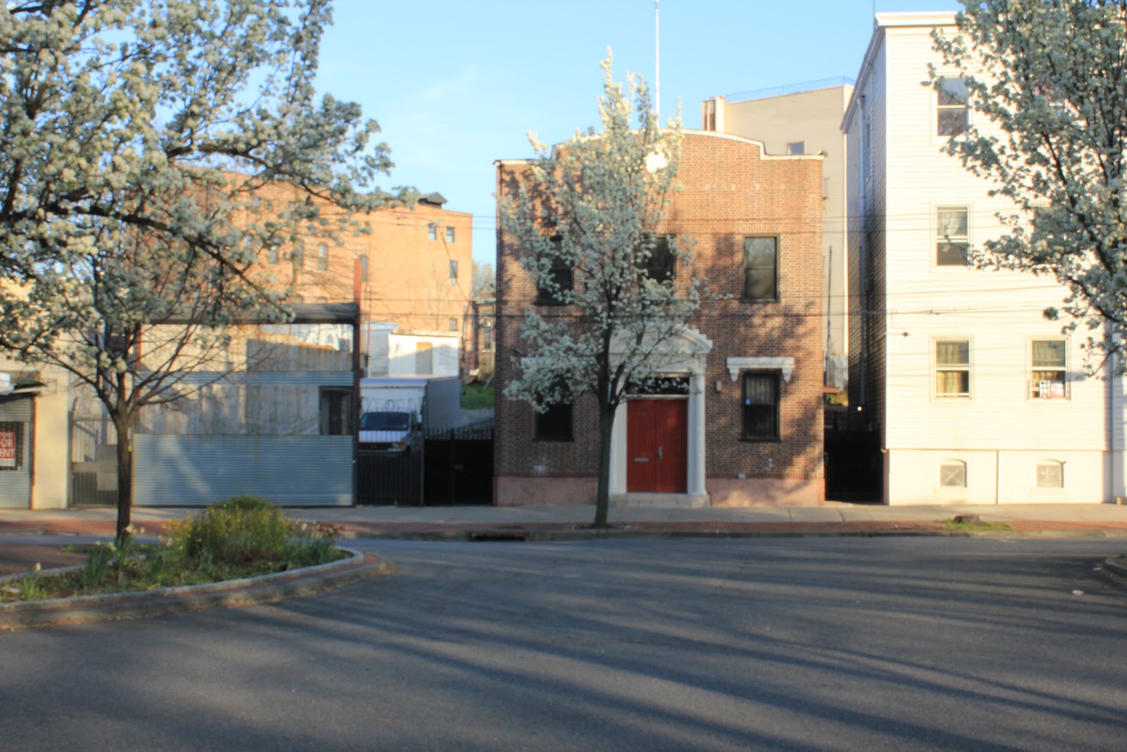
160 Canal Street - 1932 - 1898 and 1907 maps list is as being the Hein home


160 Canal Street - today - this wonderfully odd house still stands though, mysteriously, the first floor windows in the front are boarded over.


from right to left - 209 to 232 Canal Street - 1936


215, 217, 219 Canal Street - today - all that remains of the commercial properties that once ranged from Wright Street to Cedar Street on the west side of Canal.  The radio shop on  the left of the old picture was only recently demolished.


Finally, the centerpiece of the block - The Rubsam & Horrmann Atlantic Brewery.  I'm not sure when it was built though a decent portion of the plant is shown on the 1874 map of the area (below).  


The top picture (1936) was taken from where Broad and Canal meet looking north toward Wright Street.  At the far right you can make out the building in the lower picture (1930) which the maps designates a garage and storage facility.  That clock tower forms such a part of my childhood memory.  My buddy, Mike G., claimed his older friends had actually climbed up inside of it.  Before I got my chance, and based on later exploits I definitely would have tried, it was gone.  It was torn down in 1976 when I was ten.  Later the city helped build housing much of the site and a park was created on the denuded stretch of Canal Street.  It looked derelict then and only more so now.


Canal, Cedar, Boyd and Wright - 2012 - look at the transformation and desolation of the once vibrant commercial and industrial block.


Tuesday, March 27, 2012

More Van Duzer Pictures

   A few more landmarks from Van Duzer and nearby blocks.  


Fire Engine Co. 154 - This magnificent building still stands now converted to residential use.


This beautiful bit of advertising stood on that corner (Hannah btw Van Duzer and Bay) for decades only coming down in the late nineties (I think).  It was torn down to make way for a car wash.  Foolish if you ask me.


   Our Lady of Consolation - Actually on St. Paul's Avenue but its large hall (behind it) was on Van Duzer.  Today it's a dentist's parking lot.  To its left is the derelict Fire Engine Co. 204 house.